You are here: Home > Network List > CI - Caltech Regional Seismic Network Stations List
> Station MPM Manuel Prospect Mine, California, USA > Earthquake Result Viewer
MPM Manuel Prospect Mine, California, USA - Earthquake Result Viewer
| Earthquake location: |
Solomon Islands |
| Earthquake latitude/longitude: |
-6.2/155.1 |
| Earthquake time(UTC): |
2017/01/22 (022) 04:30:23 GMT |
| Earthquake Depth: |
136 km |
| Earthquake Magnitude: |
7.9 mww |
| Earthquake Catalog/Contributor: |
NEIC PDE/us |
|
| Network: |
CI Caltech Regional Seismic Network |
| Station: |
MPM Manuel Prospect Mine, California, USA |
| Lat/Lon: |
36.06 N/117.49 W |
| Elevation: |
185 m |
|
| Distance: |
91.5 deg |
| Az: |
54.07 deg |
| Baz: |
263.471 deg |
| Ray Param: |
0.041539777 |
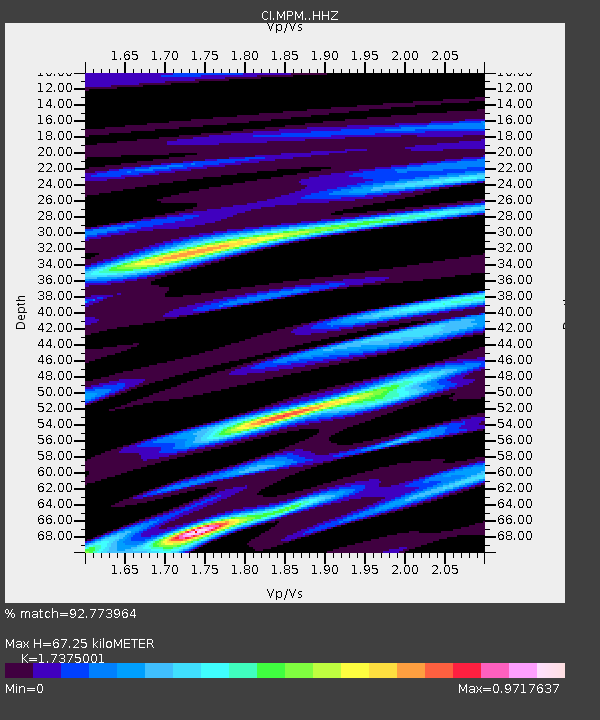
| Estimated Moho Depth: |
67.25 km |
| Estimated Crust Vp/Vs: |
1.74 |
| Assumed Crust Vp: |
6.279 km/s |
| Estimated Crust Vs: |
3.614 km/s |
| Estimated Crust Poisson's Ratio: |
0.25 |
|
| Radial Match: |
92.773964 % |
| Radial Bump: |
400 |
| Transverse Match: |
87.265945 % |
| Transverse Bump: |
400 |
| SOD ConfigId: |
11737051 |
| Insert Time: |
2019-04-26 16:39:55.846 +0000 |
| GWidth: |
2.5 |
| Max Bumps: |
400 |
| Tol: |
0.001 |
|
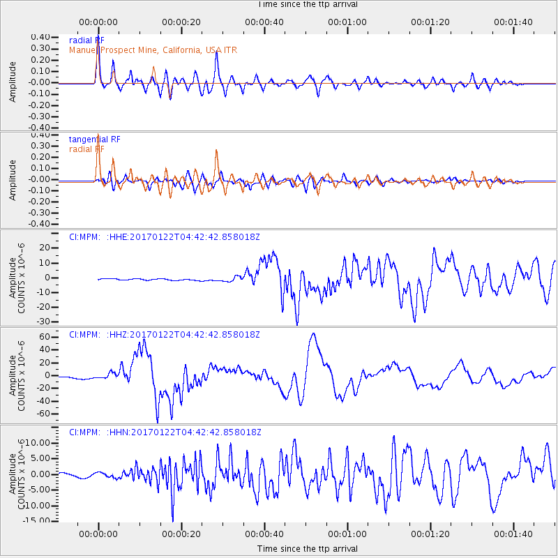
Signal To Noise
| Channel | StoN | STA | LTA |
| CI:MPM: :HHZ:20170122T04:42:42.858018Z | 3.6920793 | 4.582176E-6 | 1.2410828E-6 |
| CI:MPM: :HHN:20170122T04:42:42.858018Z | 1.2746575 | 7.9241806E-7 | 6.2167135E-7 |
| CI:MPM: :HHE:20170122T04:42:42.858018Z | 3.0238562 | 1.6228378E-6 | 5.366782E-7 |
| Arrivals |
| Ps | 8.1 SECOND |
| PpPs | 29 SECOND |
| PsPs/PpSs | 37 SECOND |


