You are here: Home > Network List > G - GEOSCOPE Stations List
> Station NOUC Port Laguerre, New Caledonia > Earthquake Result Viewer
NOUC Port Laguerre, New Caledonia - Earthquake Result Viewer
| Earthquake location: |
Andreanof Islands, Aleutian Is. |
| Earthquake latitude/longitude: |
51.7/-173.1 |
| Earthquake time(UTC): |
2015/11/09 (313) 16:03:45 GMT |
| Earthquake Depth: |
10 km |
| Earthquake Magnitude: |
6.2 MWB, 6.3 MI |
| Earthquake Catalog/Contributor: |
NEIC PDE/NEIC COMCAT |
|
| Network: |
G GEOSCOPE |
| Station: |
NOUC Port Laguerre, New Caledonia |
| Lat/Lon: |
22.10 S/166.30 E |
| Elevation: |
112 m |
|
| Distance: |
75.7 deg |
| Az: |
199.706 deg |
| Baz: |
13.068 deg |
| Ray Param: |
0.051483158 |
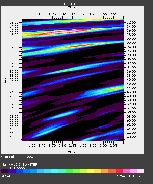
| Estimated Moho Depth: |
16.5 km |
| Estimated Crust Vp/Vs: |
1.81 |
| Assumed Crust Vp: |
5.14 km/s |
| Estimated Crust Vs: |
2.84 km/s |
| Estimated Crust Poisson's Ratio: |
0.28 |
|
| Radial Match: |
88.41206 % |
| Radial Bump: |
400 |
| Transverse Match: |
68.05648 % |
| Transverse Bump: |
400 |
| SOD ConfigId: |
1259291 |
| Insert Time: |
2015-11-23 16:57:39.184 +0000 |
| GWidth: |
2.5 |
| Max Bumps: |
400 |
| Tol: |
0.001 |
|
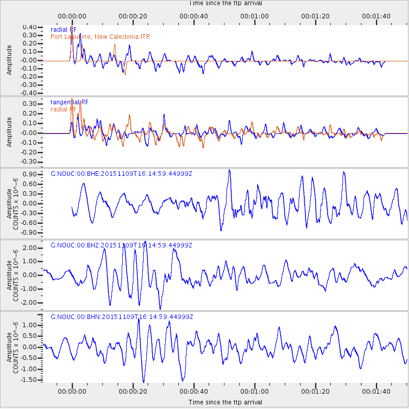
Signal To Noise
| Channel | StoN | STA | LTA |
| G:NOUC:00:BHZ:20151109T16:14:59.44999Z | 1.4546586 | 4.0948697E-7 | 2.815004E-7 |
| G:NOUC:00:BHN:20151109T16:14:59.44999Z | 1.9029754 | 3.4287254E-7 | 1.8017705E-7 |
| G:NOUC:00:BHE:20151109T16:14:59.44999Z | 0.40197858 | 1.0917378E-7 | 2.7159106E-7 |
| Arrivals |
| Ps | 2.7 SECOND |
| PpPs | 8.8 SECOND |
| PsPs/PpSs | 11 SECOND |


