You are here: Home > Network List > CI - Caltech Regional Seismic Network Stations List
> Station SWS Sam W. Stewart, Westmorland, CA, USA > Earthquake Result Viewer
SWS Sam W. Stewart, Westmorland, CA, USA - Earthquake Result Viewer
| Earthquake location: |
Solomon Islands |
| Earthquake latitude/longitude: |
-6.2/155.1 |
| Earthquake time(UTC): |
2017/01/22 (022) 04:30:23 GMT |
| Earthquake Depth: |
136 km |
| Earthquake Magnitude: |
7.9 mww |
| Earthquake Catalog/Contributor: |
NEIC PDE/us |
|
| Network: |
CI Caltech Regional Seismic Network |
| Station: |
SWS Sam W. Stewart, Westmorland, CA, USA |
| Lat/Lon: |
32.94 N/115.80 W |
| Elevation: |
140 m |
|
| Distance: |
92.6 deg |
| Az: |
57.313 deg |
| Baz: |
264.311 deg |
| Ray Param: |
0.04135571 |
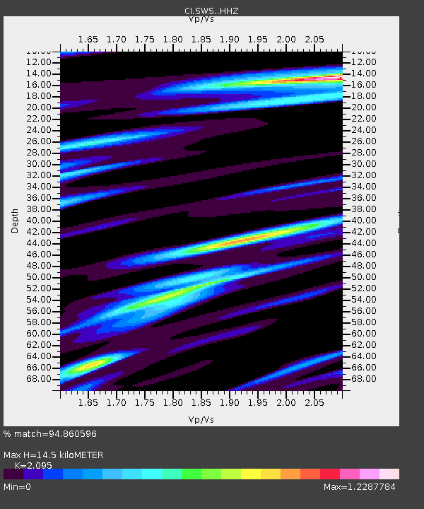
| Estimated Moho Depth: |
14.5 km |
| Estimated Crust Vp/Vs: |
2.10 |
| Assumed Crust Vp: |
6.155 km/s |
| Estimated Crust Vs: |
2.938 km/s |
| Estimated Crust Poisson's Ratio: |
0.35 |
|
| Radial Match: |
94.860596 % |
| Radial Bump: |
395 |
| Transverse Match: |
87.54357 % |
| Transverse Bump: |
400 |
| SOD ConfigId: |
11737051 |
| Insert Time: |
2019-04-26 16:40:14.421 +0000 |
| GWidth: |
2.5 |
| Max Bumps: |
400 |
| Tol: |
0.001 |
|

Signal To Noise
| Channel | StoN | STA | LTA |
| CI:SWS: :HHZ:20170122T04:42:47.718003Z | 5.6670737 | 6.7882343E-6 | 1.1978376E-6 |
| CI:SWS: :HHN:20170122T04:42:47.718003Z | 1.0490699 | 2.0333061E-6 | 1.938199E-6 |
| CI:SWS: :HHE:20170122T04:42:47.718003Z | 1.3769242 | 2.3184855E-6 | 1.6838148E-6 |
| Arrivals |
| Ps | 2.6 SECOND |
| PpPs | 7.2 SECOND |
| PsPs/PpSs | 9.8 SECOND |


