You are here: Home > Network List > GS - US Geological Survey Networks Stations List
> Station DEC06 Boomer, Decatur, IL, USA > Earthquake Result Viewer
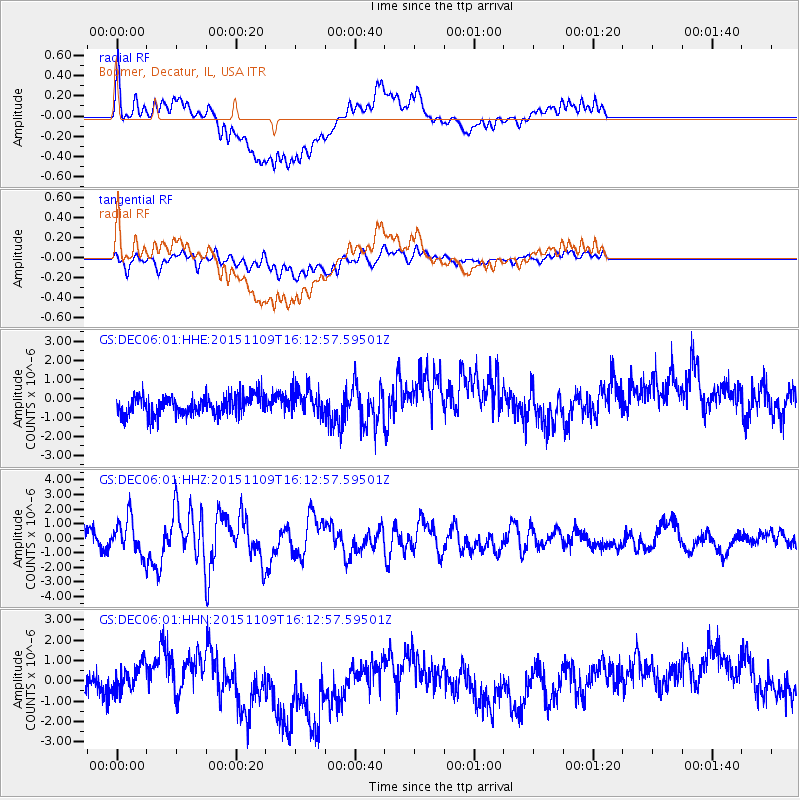
DEC06 Boomer, Decatur, IL, USA - Earthquake Result Viewer
*The percent match for this event was below the threshold and hence no stack was calculated.
| Earthquake location: |
Andreanof Islands, Aleutian Is. |
| Earthquake latitude/longitude: |
51.7/-173.1 |
| Earthquake time(UTC): |
2015/11/09 (313) 16:03:45 GMT |
| Earthquake Depth: |
10 km |
| Earthquake Magnitude: |
6.2 MWB, 6.3 MI |
| Earthquake Catalog/Contributor: |
NEIC PDE/NEIC COMCAT |
|
| Network: |
GS US Geological Survey Networks |
| Station: |
DEC06 Boomer, Decatur, IL, USA |
| Lat/Lon: |
39.90 N/88.95 W |
| Elevation: |
215 m |
|
| Distance: |
56.7 deg |
| Az: |
66.323 deg |
| Baz: |
312.244 deg |
| Ray Param: |
$rayparam |
*The percent match for this event was below the threshold and hence was not used in the summary stack. |
|
| Radial Match: |
48.8418 % |
| Radial Bump: |
400 |
| Transverse Match: |
45.102802 % |
| Transverse Bump: |
400 |
| SOD ConfigId: |
1259291 |
| Insert Time: |
2015-11-23 16:58:07.210 +0000 |
| GWidth: |
2.5 |
| Max Bumps: |
400 |
| Tol: |
0.001 |
|
Signal To Noise
| Channel | StoN | STA | LTA |
| GS:DEC06:01:HHZ:20151109T16:12:57.59501Z | 2.6426528 | 1.2038274E-6 | 4.5553747E-7 |
| GS:DEC06:01:HHN:20151109T16:12:57.59501Z | 1.1127284 | 8.5875456E-7 | 7.7175577E-7 |
| GS:DEC06:01:HHE:20151109T16:12:57.59501Z | 1.352627 | 6.953784E-7 | 5.1409467E-7 |
| Arrivals |
| Ps | |
| PpPs | |
| PsPs/PpSs | |


