You are here: Home > Network List > CI - Caltech Regional Seismic Network Stations List
> Station DJJ Donna Jones Jenkins, California, USA > Earthquake Result Viewer
DJJ Donna Jones Jenkins, California, USA - Earthquake Result Viewer
| Earthquake location: |
Tonga Islands |
| Earthquake latitude/longitude: |
-17.2/-173.9 |
| Earthquake time(UTC): |
2000/09/26 (270) 06:17:52 GMT |
| Earthquake Depth: |
56 km |
| Earthquake Magnitude: |
6.1 MB, 6.1 MS, 6.4 MW, 6.1 ME |
| Earthquake Catalog/Contributor: |
WHDF/NEIC |
|
| Network: |
CI Caltech Regional Seismic Network |
| Station: |
DJJ Donna Jones Jenkins, California, USA |
| Lat/Lon: |
34.11 N/118.45 W |
| Elevation: |
245 m |
|
| Distance: |
73.4 deg |
| Az: |
45.507 deg |
| Baz: |
235.269 deg |
| Ray Param: |
0.05291875 |
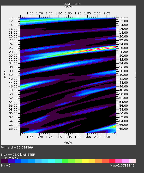
| Estimated Moho Depth: |
26.0 km |
| Estimated Crust Vp/Vs: |
2.03 |
| Assumed Crust Vp: |
6.1 km/s |
| Estimated Crust Vs: |
3.012 km/s |
| Estimated Crust Poisson's Ratio: |
0.34 |
|
| Radial Match: |
90.084366 % |
| Radial Bump: |
400 |
| Transverse Match: |
88.55997 % |
| Transverse Bump: |
400 |
| SOD ConfigId: |
3787 |
| Insert Time: |
2010-03-05 21:46:40.143 +0000 |
| GWidth: |
2.5 |
| Max Bumps: |
400 |
| Tol: |
0.001 |
|
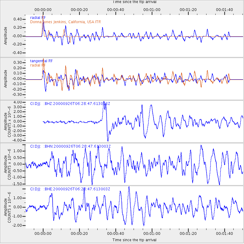
Signal To Noise
| Channel | StoN | STA | LTA |
| CI:DJJ: :BHN:20000926T06:28:47.613003Z | 1.6436075 | 2.693376E-7 | 1.6386979E-7 |
| CI:DJJ: :BHE:20000926T06:28:47.613003Z | 3.9312143 | 6.6236277E-7 | 1.6848809E-7 |
| CI:DJJ: :BHZ:20000926T06:28:47.613003Z | 17.589365 | 2.010604E-6 | 1.1430793E-7 |
| Arrivals |
| Ps | 4.5 SECOND |
| PpPs | 13 SECOND |
| PsPs/PpSs | 17 SECOND |


