You are here: Home > Network List > IU - Global Seismograph Network (GSN - IRIS/USGS) Stations List
> Station KBL Kabul, Afghanistan > Earthquake Result Viewer
KBL Kabul, Afghanistan - Earthquake Result Viewer
| Earthquake location: |
Solomon Islands |
| Earthquake latitude/longitude: |
-6.2/155.1 |
| Earthquake time(UTC): |
2017/01/22 (022) 04:30:23 GMT |
| Earthquake Depth: |
136 km |
| Earthquake Magnitude: |
7.9 mww |
| Earthquake Catalog/Contributor: |
NEIC PDE/us |
|
| Network: |
IU Global Seismograph Network (GSN - IRIS/USGS) |
| Station: |
KBL Kabul, Afghanistan |
| Lat/Lon: |
34.54 N/69.04 E |
| Elevation: |
1920 m |
|
| Distance: |
90.3 deg |
| Az: |
304.556 deg |
| Baz: |
97.304 deg |
| Ray Param: |
0.041657876 |
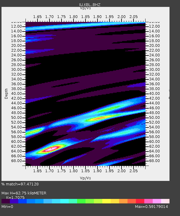
| Estimated Moho Depth: |
62.75 km |
| Estimated Crust Vp/Vs: |
1.71 |
| Assumed Crust Vp: |
6.641 km/s |
| Estimated Crust Vs: |
3.889 km/s |
| Estimated Crust Poisson's Ratio: |
0.24 |
|
| Radial Match: |
97.47128 % |
| Radial Bump: |
282 |
| Transverse Match: |
94.957436 % |
| Transverse Bump: |
372 |
| SOD ConfigId: |
11737051 |
| Insert Time: |
2019-04-26 16:41:41.550 +0000 |
| GWidth: |
2.5 |
| Max Bumps: |
400 |
| Tol: |
0.001 |
|
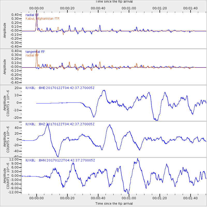
Signal To Noise
| Channel | StoN | STA | LTA |
| IU:KBL: :BHZ:20170122T04:42:37.270005Z | 14.661187 | 1.3299784E-5 | 9.071424E-7 |
| IU:KBL: :BHN:20170122T04:42:37.270005Z | 17.373163 | 5.584429E-7 | 3.2143998E-8 |
| IU:KBL: :BHE:20170122T04:42:37.270005Z | 10.911145 | 4.2201873E-6 | 3.8677769E-7 |
| Arrivals |
| Ps | 6.8 SECOND |
| PpPs | 25 SECOND |
| PsPs/PpSs | 32 SECOND |


