You are here: Home > Network List > JP - Japan Meteorological Agency Seismic Network Stations List
> Station JGF Gifu Kurokawa > Earthquake Result Viewer
JGF Gifu Kurokawa - Earthquake Result Viewer
| Earthquake location: |
Solomon Islands |
| Earthquake latitude/longitude: |
-6.2/155.1 |
| Earthquake time(UTC): |
2017/01/22 (022) 04:30:23 GMT |
| Earthquake Depth: |
136 km |
| Earthquake Magnitude: |
7.9 mww |
| Earthquake Catalog/Contributor: |
NEIC PDE/us |
|
| Network: |
JP Japan Meteorological Agency Seismic Network |
| Station: |
JGF Gifu Kurokawa |
| Lat/Lon: |
35.60 N/137.35 E |
| Elevation: |
580 m |
|
| Distance: |
44.8 deg |
| Az: |
339.345 deg |
| Baz: |
154.51 deg |
| Ray Param: |
0.071172714 |
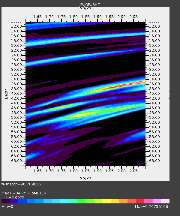
| Estimated Moho Depth: |
34.75 km |
| Estimated Crust Vp/Vs: |
2.10 |
| Assumed Crust Vp: |
6.461 km/s |
| Estimated Crust Vs: |
3.081 km/s |
| Estimated Crust Poisson's Ratio: |
0.35 |
|
| Radial Match: |
96.789665 % |
| Radial Bump: |
298 |
| Transverse Match: |
87.48401 % |
| Transverse Bump: |
400 |
| SOD ConfigId: |
11737051 |
| Insert Time: |
2019-04-26 16:41:46.900 +0000 |
| GWidth: |
2.5 |
| Max Bumps: |
400 |
| Tol: |
0.001 |
|

Signal To Noise
| Channel | StoN | STA | LTA |
| JP:JGF: :BHZ:20170122T04:37:53.15001Z | 28.132975 | 3.1255484E-5 | 1.1109911E-6 |
| JP:JGF: :BHN:20170122T04:37:53.15001Z | 13.454158 | 1.4799802E-5 | 1.1000169E-6 |
| JP:JGF: :BHE:20170122T04:37:53.15001Z | 12.074811 | 6.698476E-6 | 5.5474794E-7 |
| Arrivals |
| Ps | 6.2 SECOND |
| PpPs | 16 SECOND |
| PsPs/PpSs | 22 SECOND |


