You are here: Home > Network List > CI - Caltech Regional Seismic Network Stations List
> Station DJJ Donna Jones Jenkins, California, USA > Earthquake Result Viewer
DJJ Donna Jones Jenkins, California, USA - Earthquake Result Viewer
| Earthquake location: |
South Of Mariana Islands |
| Earthquake latitude/longitude: |
12.7/145.0 |
| Earthquake time(UTC): |
2001/10/12 (285) 15:02:16 GMT |
| Earthquake Depth: |
37 km |
| Earthquake Magnitude: |
6.7 MB, 7.3 MS, 7.0 MW, 6.9 MW |
| Earthquake Catalog/Contributor: |
WHDF/NEIC |
|
| Network: |
CI Caltech Regional Seismic Network |
| Station: |
DJJ Donna Jones Jenkins, California, USA |
| Lat/Lon: |
34.11 N/118.45 W |
| Elevation: |
245 m |
|
| Distance: |
88.3 deg |
| Az: |
55.553 deg |
| Baz: |
284.09 deg |
| Ray Param: |
0.042617854 |
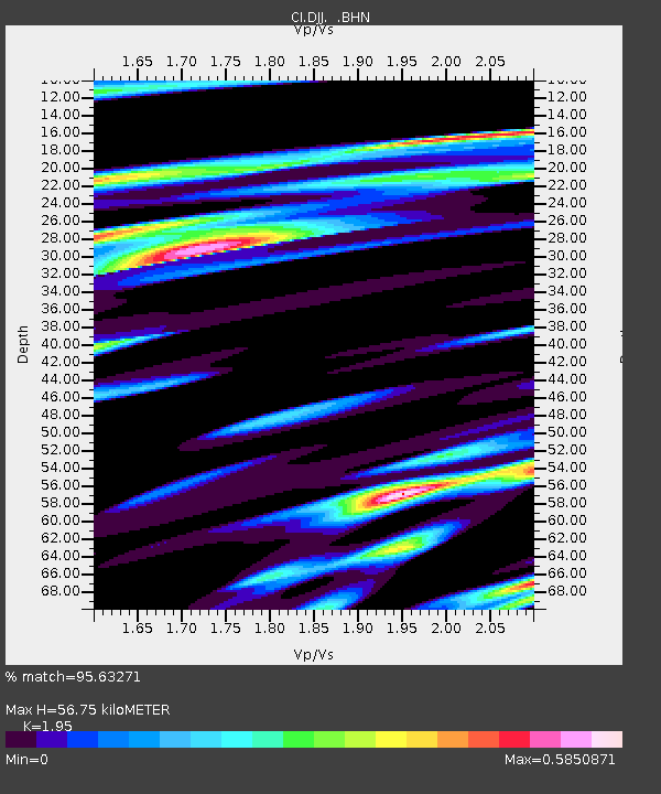
| Estimated Moho Depth: |
56.75 km |
| Estimated Crust Vp/Vs: |
1.95 |
| Assumed Crust Vp: |
6.1 km/s |
| Estimated Crust Vs: |
3.128 km/s |
| Estimated Crust Poisson's Ratio: |
0.32 |
|
| Radial Match: |
95.63271 % |
| Radial Bump: |
400 |
| Transverse Match: |
93.02268 % |
| Transverse Bump: |
400 |
| SOD ConfigId: |
3787 |
| Insert Time: |
2010-03-05 21:47:05.795 +0000 |
| GWidth: |
2.5 |
| Max Bumps: |
400 |
| Tol: |
0.001 |
|
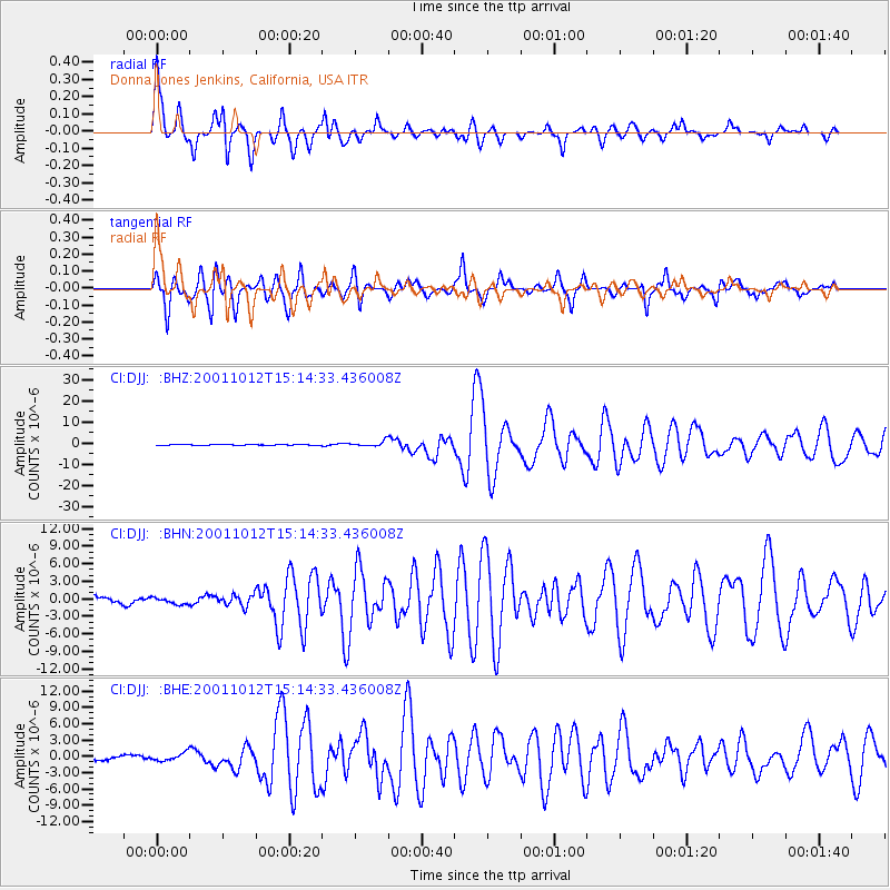
Signal To Noise
| Channel | StoN | STA | LTA |
| CI:DJJ: :BHN:20011012T15:14:33.436008Z | 0.9931564 | 5.5702907E-7 | 5.608674E-7 |
| CI:DJJ: :BHE:20011012T15:14:33.436008Z | 1.0500894 | 7.1244733E-7 | 6.784636E-7 |
| CI:DJJ: :BHZ:20011012T15:14:33.436008Z | 6.353866 | 1.2131954E-6 | 1.9093814E-7 |
| Arrivals |
| Ps | 9.0 SECOND |
| PpPs | 27 SECOND |
| PsPs/PpSs | 36 SECOND |


