You are here: Home > Network List > CI - Caltech Regional Seismic Network Stations List
> Station DJJ Donna Jones Jenkins, California, USA > Earthquake Result Viewer
DJJ Donna Jones Jenkins, California, USA - Earthquake Result Viewer
| Earthquake location: |
Northwest Of Kuril Islands |
| Earthquake latitude/longitude: |
47.8/146.2 |
| Earthquake time(UTC): |
2002/11/17 (321) 04:53:53 GMT |
| Earthquake Depth: |
459 km |
| Earthquake Magnitude: |
7.3 MW, 7.3 MW |
| Earthquake Catalog/Contributor: |
WHDF/NEIC |
|
| Network: |
CI Caltech Regional Seismic Network |
| Station: |
DJJ Donna Jones Jenkins, California, USA |
| Lat/Lon: |
34.11 N/118.45 W |
| Elevation: |
245 m |
|
| Distance: |
68.9 deg |
| Az: |
62.332 deg |
| Baz: |
314.004 deg |
| Ray Param: |
0.054501474 |
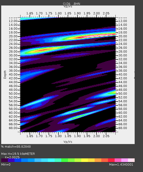
| Estimated Moho Depth: |
19.5 km |
| Estimated Crust Vp/Vs: |
2.00 |
| Assumed Crust Vp: |
6.1 km/s |
| Estimated Crust Vs: |
3.046 km/s |
| Estimated Crust Poisson's Ratio: |
0.33 |
|
| Radial Match: |
88.82848 % |
| Radial Bump: |
400 |
| Transverse Match: |
74.30036 % |
| Transverse Bump: |
400 |
| SOD ConfigId: |
3787 |
| Insert Time: |
2010-03-05 21:47:13.477 +0000 |
| GWidth: |
2.5 |
| Max Bumps: |
400 |
| Tol: |
0.001 |
|

Signal To Noise
| Channel | StoN | STA | LTA |
| CI:DJJ: :BHN:20021117T05:03:40.165Z | 24.869913 | 1.2133642E-5 | 4.878844E-7 |
| CI:DJJ: :BHE:20021117T05:03:40.165Z | 32.748917 | 1.0086821E-5 | 3.0800473E-7 |
| CI:DJJ: :BHZ:20021117T05:03:40.165Z | 79.5107 | 3.1472213E-5 | 3.9582363E-7 |
| Arrivals |
| Ps | 3.3 SECOND |
| PpPs | 9.3 SECOND |
| PsPs/PpSs | 13 SECOND |


