You are here: Home > Network List > NY - Yukon Northwest Seismic Network(YNSN) Stations List
> Station WTLY Watson Lake, Yukon, CANADA > Earthquake Result Viewer
WTLY Watson Lake, Yukon, CANADA - Earthquake Result Viewer
| Earthquake location: |
Solomon Islands |
| Earthquake latitude/longitude: |
-6.2/155.1 |
| Earthquake time(UTC): |
2017/01/22 (022) 04:30:23 GMT |
| Earthquake Depth: |
136 km |
| Earthquake Magnitude: |
7.9 mww |
| Earthquake Catalog/Contributor: |
NEIC PDE/us |
|
| Network: |
NY Yukon Northwest Seismic Network(YNSN) |
| Station: |
WTLY Watson Lake, Yukon, CANADA |
| Lat/Lon: |
60.11 N/128.80 W |
| Elevation: |
0.0 m |
|
| Distance: |
88.5 deg |
| Az: |
29.096 deg |
| Baz: |
254.874 deg |
| Ray Param: |
0.042264175 |
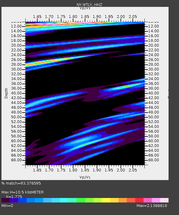
| Estimated Moho Depth: |
10.5 km |
| Estimated Crust Vp/Vs: |
1.77 |
| Assumed Crust Vp: |
6.35 km/s |
| Estimated Crust Vs: |
3.577 km/s |
| Estimated Crust Poisson's Ratio: |
0.27 |
|
| Radial Match: |
93.376595 % |
| Radial Bump: |
361 |
| Transverse Match: |
90.67969 % |
| Transverse Bump: |
398 |
| SOD ConfigId: |
11737051 |
| Insert Time: |
2019-04-26 16:42:55.601 +0000 |
| GWidth: |
2.5 |
| Max Bumps: |
400 |
| Tol: |
0.001 |
|

Signal To Noise
| Channel | StoN | STA | LTA |
| NY:WTLY: :HHZ:20170122T04:42:28.819993Z | 15.105045 | 1.6208205E-5 | 1.0730325E-6 |
| NY:WTLY: :HHN:20170122T04:42:28.819993Z | 2.245055 | 1.6162588E-6 | 7.199195E-7 |
| NY:WTLY: :HHE:20170122T04:42:28.819993Z | 10.278097 | 5.9509152E-6 | 5.7899E-7 |
| Arrivals |
| Ps | 1.3 SECOND |
| PpPs | 4.5 SECOND |
| PsPs/PpSs | 5.8 SECOND |


