You are here: Home > Network List > S - Seismographs in Schools Projects Stations List
> Station AULHS Lilydale High School, Lilydale, TAS > Earthquake Result Viewer
AULHS Lilydale High School, Lilydale, TAS - Earthquake Result Viewer
| Earthquake location: |
Solomon Islands |
| Earthquake latitude/longitude: |
-6.2/155.1 |
| Earthquake time(UTC): |
2017/01/22 (022) 04:30:23 GMT |
| Earthquake Depth: |
136 km |
| Earthquake Magnitude: |
7.9 mww |
| Earthquake Catalog/Contributor: |
NEIC PDE/us |
|
| Network: |
S Seismographs in Schools Projects |
| Station: |
AULHS Lilydale High School, Lilydale, TAS |
| Lat/Lon: |
41.25 S/147.21 E |
| Elevation: |
173 m |
|
| Distance: |
35.6 deg |
| Az: |
190.265 deg |
| Baz: |
13.59 deg |
| Ray Param: |
0.0766697 |
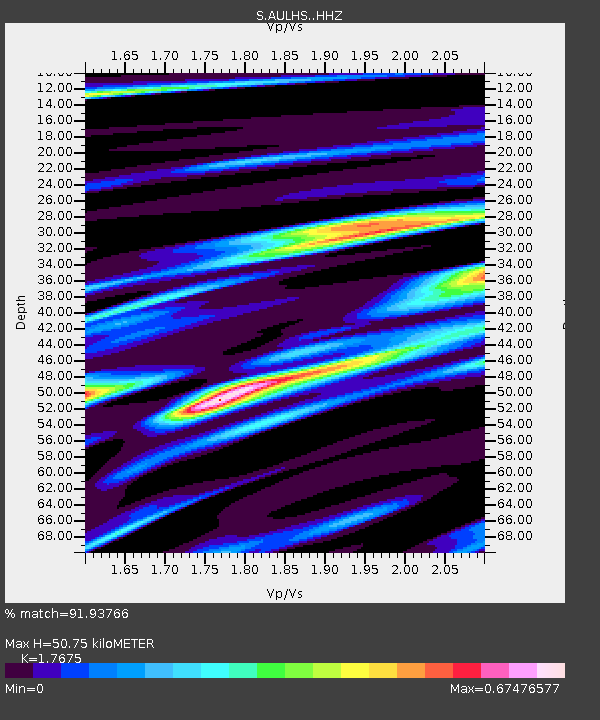
| Estimated Moho Depth: |
50.75 km |
| Estimated Crust Vp/Vs: |
1.77 |
| Assumed Crust Vp: |
6.39 km/s |
| Estimated Crust Vs: |
3.615 km/s |
| Estimated Crust Poisson's Ratio: |
0.26 |
|
| Radial Match: |
91.93766 % |
| Radial Bump: |
400 |
| Transverse Match: |
91.76222 % |
| Transverse Bump: |
245 |
| SOD ConfigId: |
11737051 |
| Insert Time: |
2019-04-26 16:43:43.365 +0000 |
| GWidth: |
2.5 |
| Max Bumps: |
400 |
| Tol: |
0.001 |
|

Signal To Noise
| Channel | StoN | STA | LTA |
| S:AULHS: :HHZ:20170122T04:36:37.229996Z | 15.656587 | 1.4112412E-5 | 9.0137223E-7 |
| S:AULHS: :HHN:20170122T04:36:37.229996Z | 14.886694 | 8.371141E-6 | 5.623237E-7 |
| S:AULHS: :HHE:20170122T04:36:37.229996Z | 9.691976 | 4.646269E-6 | 4.793934E-7 |
| Arrivals |
| Ps | 6.6 SECOND |
| PpPs | 20 SECOND |
| PsPs/PpSs | 27 SECOND |


