You are here: Home > Network List > TA - USArray Transportable Network (new EarthScope stations) Stations List
> Station H21K Melozitna River, AK, USA > Earthquake Result Viewer
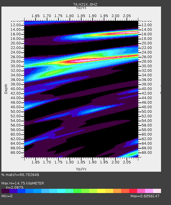
H21K Melozitna River, AK, USA - Earthquake Result Viewer
| Earthquake location: |
Solomon Islands |
| Earthquake latitude/longitude: |
-6.2/155.1 |
| Earthquake time(UTC): |
2017/01/22 (022) 04:30:23 GMT |
| Earthquake Depth: |
136 km |
| Earthquake Magnitude: |
7.9 mww |
| Earthquake Catalog/Contributor: |
NEIC PDE/us |
|
| Network: |
TA USArray Transportable Network (new EarthScope stations) |
| Station: |
H21K Melozitna River, AK, USA |
| Lat/Lon: |
65.66 N/152.80 W |
| Elevation: |
520 m |
|
| Distance: |
81.1 deg |
| Az: |
19.328 deg |
| Baz: |
232.548 deg |
| Ray Param: |
0.047532775 |
| Estimated Moho Depth: |
14.75 km |
| Estimated Crust Vp/Vs: |
2.10 |
| Assumed Crust Vp: |
6.566 km/s |
| Estimated Crust Vs: |
3.13 km/s |
| Estimated Crust Poisson's Ratio: |
0.35 |
|
| Radial Match: |
98.782646 % |
| Radial Bump: |
248 |
| Transverse Match: |
93.42452 % |
| Transverse Bump: |
400 |
| SOD ConfigId: |
11737051 |
| Insert Time: |
2019-04-26 16:44:08.818 +0000 |
| GWidth: |
2.5 |
| Max Bumps: |
400 |
| Tol: |
0.001 |
|

Signal To Noise
| Channel | StoN | STA | LTA |
| TA:H21K: :BHZ:20170122T04:41:51.874985Z | 15.699721 | 1.8687955E-5 | 1.1903368E-6 |
| TA:H21K: :BHN:20170122T04:41:51.874985Z | 9.528018 | 3.8338035E-6 | 4.023716E-7 |
| TA:H21K: :BHE:20170122T04:41:51.874985Z | 11.418926 | 5.5009073E-6 | 4.81736E-7 |
| Arrivals |
| Ps | 2.5 SECOND |
| PpPs | 6.8 SECOND |
| PsPs/PpSs | 9.3 SECOND |


