You are here: Home > Network List > TA - USArray Transportable Network (new EarthScope stations) Stations List
> Station I27K Kandik River, AK, USA > Earthquake Result Viewer
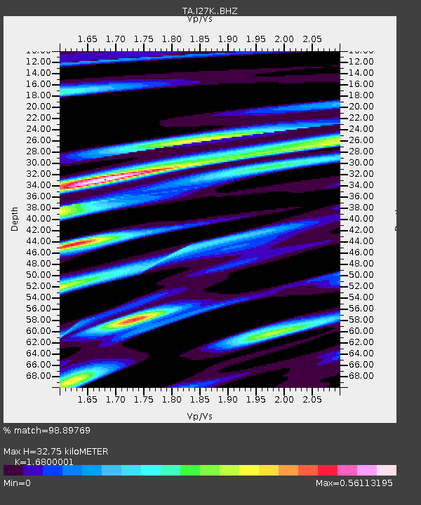
I27K Kandik River, AK, USA - Earthquake Result Viewer
| Earthquake location: |
Solomon Islands |
| Earthquake latitude/longitude: |
-6.2/155.1 |
| Earthquake time(UTC): |
2017/01/22 (022) 04:30:23 GMT |
| Earthquake Depth: |
136 km |
| Earthquake Magnitude: |
7.9 mww |
| Earthquake Catalog/Contributor: |
NEIC PDE/us |
|
| Network: |
TA USArray Transportable Network (new EarthScope stations) |
| Station: |
I27K Kandik River, AK, USA |
| Lat/Lon: |
65.60 N/141.62 W |
| Elevation: |
874 m |
|
| Distance: |
85.0 deg |
| Az: |
21.863 deg |
| Baz: |
243.044 deg |
| Ray Param: |
0.044805914 |
| Estimated Moho Depth: |
32.75 km |
| Estimated Crust Vp/Vs: |
1.68 |
| Assumed Crust Vp: |
6.566 km/s |
| Estimated Crust Vs: |
3.908 km/s |
| Estimated Crust Poisson's Ratio: |
0.23 |
|
| Radial Match: |
98.89769 % |
| Radial Bump: |
396 |
| Transverse Match: |
95.62902 % |
| Transverse Bump: |
400 |
| SOD ConfigId: |
11737051 |
| Insert Time: |
2019-04-26 16:44:14.482 +0000 |
| GWidth: |
2.5 |
| Max Bumps: |
400 |
| Tol: |
0.001 |
|

Signal To Noise
| Channel | StoN | STA | LTA |
| TA:I27K: :BHZ:20170122T04:42:11.824998Z | 17.362059 | 1.984155E-5 | 1.1428109E-6 |
| TA:I27K: :BHN:20170122T04:42:11.824998Z | 8.789711 | 3.375451E-6 | 3.8402294E-7 |
| TA:I27K: :BHE:20170122T04:42:11.824998Z | 14.110461 | 6.4959804E-6 | 4.6036627E-7 |
| Arrivals |
| Ps | 3.5 SECOND |
| PpPs | 13 SECOND |
| PsPs/PpSs | 16 SECOND |


