You are here: Home > Network List > TA - USArray Transportable Network (new EarthScope stations) Stations List
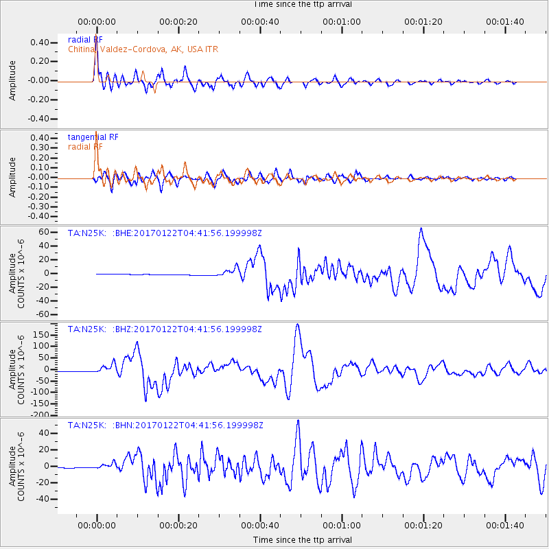
> Station N25K Chitina, Valdez-Cordova, AK, USA > Earthquake Result Viewer
N25K Chitina, Valdez-Cordova, AK, USA - Earthquake Result Viewer
| Earthquake location: |
Solomon Islands |
| Earthquake latitude/longitude: |
-6.2/155.1 |
| Earthquake time(UTC): |
2017/01/22 (022) 04:30:23 GMT |
| Earthquake Depth: |
136 km |
| Earthquake Magnitude: |
7.9 mww |
| Earthquake Catalog/Contributor: |
NEIC PDE/us |
|
| Network: |
TA USArray Transportable Network (new EarthScope stations) |
| Station: |
N25K Chitina, Valdez-Cordova, AK, USA |
| Lat/Lon: |
61.61 N/144.60 W |
| Elevation: |
1087 m |
|
| Distance: |
81.9 deg |
| Az: |
24.792 deg |
| Baz: |
240.71 deg |
| Ray Param: |
0.04695809 |
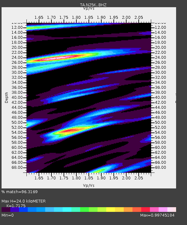
| Estimated Moho Depth: |
24.0 km |
| Estimated Crust Vp/Vs: |
1.72 |
| Assumed Crust Vp: |
6.566 km/s |
| Estimated Crust Vs: |
3.823 km/s |
| Estimated Crust Poisson's Ratio: |
0.24 |
|
| Radial Match: |
96.3169 % |
| Radial Bump: |
400 |
| Transverse Match: |
93.311775 % |
| Transverse Bump: |
400 |
| SOD ConfigId: |
11737051 |
| Insert Time: |
2019-04-26 16:44:31.612 +0000 |
| GWidth: |
2.5 |
| Max Bumps: |
400 |
| Tol: |
0.001 |
|
Signal To Noise
| Channel | StoN | STA | LTA |
| TA:N25K: :BHZ:20170122T04:41:56.199998Z | 18.046305 | 2.0856367E-5 | 1.155714E-6 |
| TA:N25K: :BHN:20170122T04:41:56.199998Z | 8.337913 | 3.6079377E-6 | 4.3271473E-7 |
| TA:N25K: :BHE:20170122T04:41:56.199998Z | 14.34484 | 6.700453E-6 | 4.670985E-7 |
| Arrivals |
| Ps | 2.7 SECOND |
| PpPs | 9.7 SECOND |
| PsPs/PpSs | 12 SECOND |


