You are here: Home > Network List > TM - Thai Seismic Monitoring Network Stations List
> Station NAYO NAYO staion > Earthquake Result Viewer
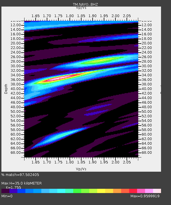
NAYO NAYO staion - Earthquake Result Viewer
| Earthquake location: |
Solomon Islands |
| Earthquake latitude/longitude: |
-6.2/155.1 |
| Earthquake time(UTC): |
2017/01/22 (022) 04:30:23 GMT |
| Earthquake Depth: |
136 km |
| Earthquake Magnitude: |
7.9 mww |
| Earthquake Catalog/Contributor: |
NEIC PDE/us |
|
| Network: |
TM Thai Seismic Monitoring Network |
| Station: |
NAYO NAYO staion |
| Lat/Lon: |
14.32 N/101.32 E |
| Elevation: |
106 m |
|
| Distance: |
57.1 deg |
| Az: |
291.354 deg |
| Baz: |
107.209 deg |
| Ray Param: |
0.06327192 |
| Estimated Moho Depth: |
35.0 km |
| Estimated Crust Vp/Vs: |
1.75 |
| Assumed Crust Vp: |
6.498 km/s |
| Estimated Crust Vs: |
3.702 km/s |
| Estimated Crust Poisson's Ratio: |
0.26 |
|
| Radial Match: |
97.582405 % |
| Radial Bump: |
323 |
| Transverse Match: |
57.63815 % |
| Transverse Bump: |
400 |
| SOD ConfigId: |
11737051 |
| Insert Time: |
2019-04-26 16:45:26.396 +0000 |
| GWidth: |
2.5 |
| Max Bumps: |
400 |
| Tol: |
0.001 |
|

Signal To Noise
| Channel | StoN | STA | LTA |
| TM:NAYO: :BHZ:20170122T04:39:24.939988Z | 22.582556 | 2.2396812E-4 | 9.917749E-6 |
| TM:NAYO: :BHN:20170122T04:39:24.939988Z | 1.4949653 | 8.233617E-5 | 5.5075638E-5 |
| TM:NAYO: :BHE:20170122T04:39:24.939988Z | 19.471172 | 1.046164E-4 | 5.372887E-6 |
| Arrivals |
| Ps | 4.3 SECOND |
| PpPs | 14 SECOND |
| PsPs/PpSs | 18 SECOND |


