You are here: Home > Network List > UW - Pacific Northwest Regional Seismic Network Stations List
> Station LTY Liberty (broad-band) > Earthquake Result Viewer
LTY Liberty (broad-band) - Earthquake Result Viewer
| Earthquake location: |
Solomon Islands |
| Earthquake latitude/longitude: |
-6.2/155.1 |
| Earthquake time(UTC): |
2017/01/22 (022) 04:30:23 GMT |
| Earthquake Depth: |
136 km |
| Earthquake Magnitude: |
7.9 mww |
| Earthquake Catalog/Contributor: |
NEIC PDE/us |
|
| Network: |
UW Pacific Northwest Regional Seismic Network |
| Station: |
LTY Liberty (broad-band) |
| Lat/Lon: |
47.26 N/120.66 W |
| Elevation: |
970 m |
|
| Distance: |
90.6 deg |
| Az: |
42.668 deg |
| Baz: |
261.568 deg |
| Ray Param: |
0.04163394 |
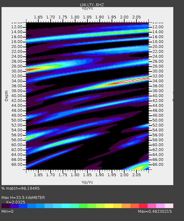
| Estimated Moho Depth: |
33.5 km |
| Estimated Crust Vp/Vs: |
2.03 |
| Assumed Crust Vp: |
6.597 km/s |
| Estimated Crust Vs: |
3.246 km/s |
| Estimated Crust Poisson's Ratio: |
0.34 |
|
| Radial Match: |
96.19495 % |
| Radial Bump: |
400 |
| Transverse Match: |
96.55597 % |
| Transverse Bump: |
400 |
| SOD ConfigId: |
11737051 |
| Insert Time: |
2019-04-26 16:46:01.338 +0000 |
| GWidth: |
2.5 |
| Max Bumps: |
400 |
| Tol: |
0.001 |
|

Signal To Noise
| Channel | StoN | STA | LTA |
| UW:LTY: :BHZ:20170122T04:42:38.665024Z | 8.009995 | 7.906722E-6 | 9.87107E-7 |
| UW:LTY: :BHN:20170122T04:42:38.665024Z | 1.7111534 | 6.0058767E-7 | 3.5098412E-7 |
| UW:LTY: :BHE:20170122T04:42:38.665024Z | 2.8264465 | 1.8384944E-6 | 6.504614E-7 |
| Arrivals |
| Ps | 5.3 SECOND |
| PpPs | 15 SECOND |
| PsPs/PpSs | 20 SECOND |


