You are here: Home > Network List > UW - Pacific Northwest Regional Seismic Network Stations List
> Station RADR Rader Ridge, WA > Earthquake Result Viewer
RADR Rader Ridge, WA - Earthquake Result Viewer
| Earthquake location: |
Solomon Islands |
| Earthquake latitude/longitude: |
-6.2/155.1 |
| Earthquake time(UTC): |
2017/01/22 (022) 04:30:23 GMT |
| Earthquake Depth: |
136 km |
| Earthquake Magnitude: |
7.9 mww |
| Earthquake Catalog/Contributor: |
NEIC PDE/us |
|
| Network: |
UW Pacific Northwest Regional Seismic Network |
| Station: |
RADR Rader Ridge, WA |
| Lat/Lon: |
46.42 N/123.80 W |
| Elevation: |
568 m |
|
| Distance: |
88.3 deg |
| Az: |
43.133 deg |
| Baz: |
259.293 deg |
| Ray Param: |
0.04236256 |
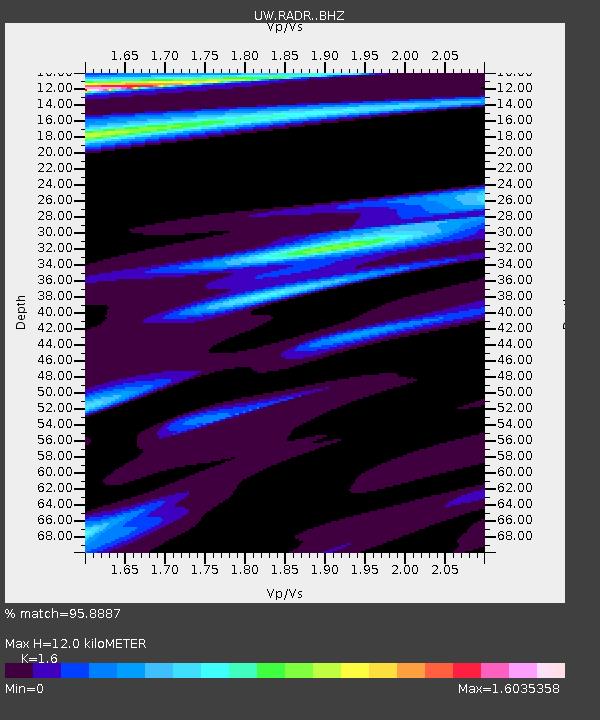
| Estimated Moho Depth: |
12.0 km |
| Estimated Crust Vp/Vs: |
1.60 |
| Assumed Crust Vp: |
6.566 km/s |
| Estimated Crust Vs: |
4.104 km/s |
| Estimated Crust Poisson's Ratio: |
0.18 |
|
| Radial Match: |
95.8887 % |
| Radial Bump: |
400 |
| Transverse Match: |
88.65214 % |
| Transverse Bump: |
400 |
| SOD ConfigId: |
11737051 |
| Insert Time: |
2019-04-26 16:46:06.102 +0000 |
| GWidth: |
2.5 |
| Max Bumps: |
400 |
| Tol: |
0.001 |
|

Signal To Noise
| Channel | StoN | STA | LTA |
| UW:RADR: :BHZ:20170122T04:42:28.189988Z | 5.9738736 | 1.07624155E-5 | 1.8015808E-6 |
| UW:RADR: :BHN:20170122T04:42:28.189988Z | 1.4137335 | 3.4858706E-6 | 2.4657197E-6 |
| UW:RADR: :BHE:20170122T04:42:28.189988Z | 0.78172344 | 1.6422268E-6 | 2.1007772E-6 |
| Arrivals |
| Ps | 1.1 SECOND |
| PpPs | 4.6 SECOND |
| PsPs/PpSs | 5.8 SECOND |


