You are here: Home > Network List > UW - Pacific Northwest Regional Seismic Network Stations List
> Station RATT Rattlesnake Lake, WA > Earthquake Result Viewer
RATT Rattlesnake Lake, WA - Earthquake Result Viewer
| Earthquake location: |
Solomon Islands |
| Earthquake latitude/longitude: |
-6.2/155.1 |
| Earthquake time(UTC): |
2017/01/22 (022) 04:30:23 GMT |
| Earthquake Depth: |
136 km |
| Earthquake Magnitude: |
7.9 mww |
| Earthquake Catalog/Contributor: |
NEIC PDE/us |
|
| Network: |
UW Pacific Northwest Regional Seismic Network |
| Station: |
RATT Rattlesnake Lake, WA |
| Lat/Lon: |
47.43 N/121.80 W |
| Elevation: |
440 m |
|
| Distance: |
89.9 deg |
| Az: |
42.381 deg |
| Baz: |
260.735 deg |
| Ray Param: |
0.041686572 |
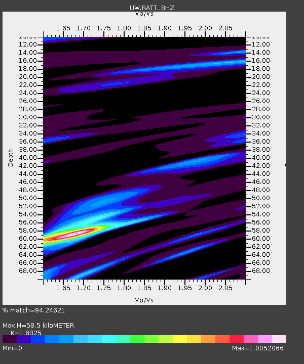
| Estimated Moho Depth: |
58.5 km |
| Estimated Crust Vp/Vs: |
1.68 |
| Assumed Crust Vp: |
6.597 km/s |
| Estimated Crust Vs: |
3.921 km/s |
| Estimated Crust Poisson's Ratio: |
0.23 |
|
| Radial Match: |
94.24621 % |
| Radial Bump: |
400 |
| Transverse Match: |
92.413795 % |
| Transverse Bump: |
400 |
| SOD ConfigId: |
11737051 |
| Insert Time: |
2019-04-26 16:46:06.445 +0000 |
| GWidth: |
2.5 |
| Max Bumps: |
400 |
| Tol: |
0.001 |
|

Signal To Noise
| Channel | StoN | STA | LTA |
| UW:RATT: :BHZ:20170122T04:42:35.265Z | 9.084467 | 9.1225E-6 | 1.0041866E-6 |
| UW:RATT: :BHN:20170122T04:42:35.265Z | 2.1049633 | 1.2348048E-6 | 5.8661584E-7 |
| UW:RATT: :BHE:20170122T04:42:35.265Z | 2.3049977 | 2.1004003E-6 | 9.1123746E-7 |
| Arrivals |
| Ps | 6.2 SECOND |
| PpPs | 23 SECOND |
| PsPs/PpSs | 29 SECOND |


