You are here: Home > Network List > X416 - Monitoring Active Faults for Tectonic Mapping Efforts in Washington State Stations List
> Station MA03B Snohomish County, WA, USA > Earthquake Result Viewer
MA03B Snohomish County, WA, USA - Earthquake Result Viewer
| Earthquake location: |
Solomon Islands |
| Earthquake latitude/longitude: |
-6.2/155.1 |
| Earthquake time(UTC): |
2017/01/22 (022) 04:30:23 GMT |
| Earthquake Depth: |
136 km |
| Earthquake Magnitude: |
7.9 mww |
| Earthquake Catalog/Contributor: |
NEIC PDE/us |
|
| Network: |
X4 Monitoring Active Faults for Tectonic Mapping Efforts in Washington State |
| Station: |
MA03B Snohomish County, WA, USA |
| Lat/Lon: |
47.96 N/121.78 W |
| Elevation: |
-1.0 m |
|
| Distance: |
90.0 deg |
| Az: |
41.851 deg |
| Baz: |
260.749 deg |
| Ray Param: |
0.04167941 |
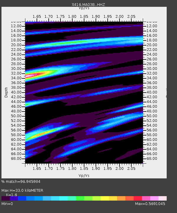
| Estimated Moho Depth: |
33.0 km |
| Estimated Crust Vp/Vs: |
1.60 |
| Assumed Crust Vp: |
6.597 km/s |
| Estimated Crust Vs: |
4.123 km/s |
| Estimated Crust Poisson's Ratio: |
0.18 |
|
| Radial Match: |
96.945984 % |
| Radial Bump: |
400 |
| Transverse Match: |
92.456184 % |
| Transverse Bump: |
400 |
| SOD ConfigId: |
11737051 |
| Insert Time: |
2019-04-26 16:46:18.245 +0000 |
| GWidth: |
2.5 |
| Max Bumps: |
400 |
| Tol: |
0.001 |
|

Signal To Noise
| Channel | StoN | STA | LTA |
| X4:MA03B: :HHZ:20170122T04:42:35.725022Z | 9.963184 | 9.428227E-6 | 9.4630656E-7 |
| X4:MA03B: :HHN:20170122T04:42:35.725022Z | 3.834142 | 1.4360554E-6 | 3.7454413E-7 |
| X4:MA03B: :HHE:20170122T04:42:35.725022Z | 5.233534 | 1.9134707E-6 | 3.656173E-7 |
| Arrivals |
| Ps | 3.1 SECOND |
| PpPs | 13 SECOND |
| PsPs/PpSs | 16 SECOND |


