You are here: Home > Network List > X416 - Monitoring Active Faults for Tectonic Mapping Efforts in Washington State Stations List
> Station LR13 Thurston County, WA, USA > Earthquake Result Viewer
LR13 Thurston County, WA, USA - Earthquake Result Viewer
| Earthquake location: |
Solomon Islands |
| Earthquake latitude/longitude: |
-6.2/155.1 |
| Earthquake time(UTC): |
2017/01/22 (022) 04:30:23 GMT |
| Earthquake Depth: |
136 km |
| Earthquake Magnitude: |
7.9 mww |
| Earthquake Catalog/Contributor: |
NEIC PDE/us |
|
| Network: |
X4 Monitoring Active Faults for Tectonic Mapping Efforts in Washington State |
| Station: |
LR13 Thurston County, WA, USA |
| Lat/Lon: |
46.95 N/122.96 W |
| Elevation: |
-1.0 m |
|
| Distance: |
89.0 deg |
| Az: |
42.716 deg |
| Baz: |
259.889 deg |
| Ray Param: |
0.041881945 |
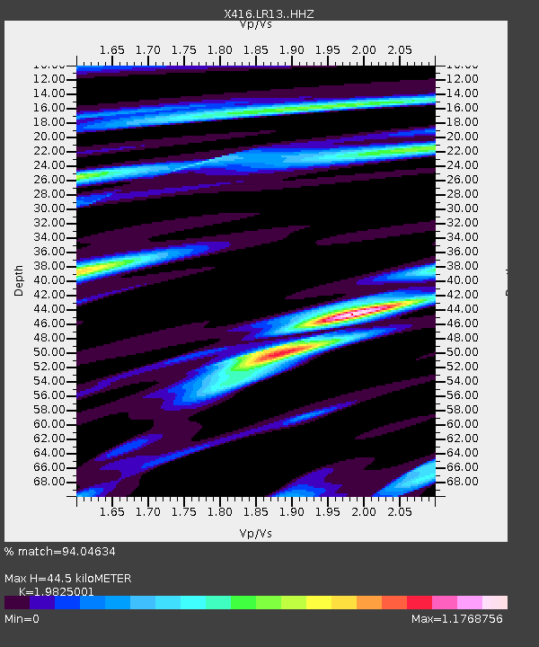
| Estimated Moho Depth: |
44.5 km |
| Estimated Crust Vp/Vs: |
1.98 |
| Assumed Crust Vp: |
6.566 km/s |
| Estimated Crust Vs: |
3.312 km/s |
| Estimated Crust Poisson's Ratio: |
0.33 |
|
| Radial Match: |
94.04634 % |
| Radial Bump: |
400 |
| Transverse Match: |
88.99349 % |
| Transverse Bump: |
400 |
| SOD ConfigId: |
11737051 |
| Insert Time: |
2019-04-26 16:46:19.100 +0000 |
| GWidth: |
2.5 |
| Max Bumps: |
400 |
| Tol: |
0.001 |
|

Signal To Noise
| Channel | StoN | STA | LTA |
| X4:LR13: :HHZ:20170122T04:42:31.265Z | 9.085489 | 8.856658E-6 | 9.748135E-7 |
| X4:LR13: :HHN:20170122T04:42:31.265Z | 3.3474221 | 1.9322274E-6 | 5.772285E-7 |
| X4:LR13: :HHE:20170122T04:42:31.265Z | 3.2396886 | 1.7322038E-6 | 5.346822E-7 |
| Arrivals |
| Ps | 6.8 SECOND |
| PpPs | 20 SECOND |
| PsPs/PpSs | 27 SECOND |


