You are here: Home > Network List > YN10 - San Jacinto Fault Zone Stations List
> Station TR04 TR04 > Earthquake Result Viewer
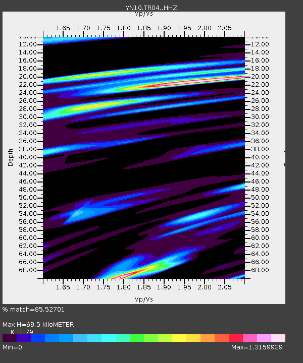
TR04 TR04 - Earthquake Result Viewer
| Earthquake location: |
Solomon Islands |
| Earthquake latitude/longitude: |
-6.2/155.1 |
| Earthquake time(UTC): |
2017/01/22 (022) 04:30:23 GMT |
| Earthquake Depth: |
136 km |
| Earthquake Magnitude: |
7.9 mww |
| Earthquake Catalog/Contributor: |
NEIC PDE/us |
|
| Network: |
YN San Jacinto Fault Zone |
| Station: |
TR04 TR04 |
| Lat/Lon: |
33.40 N/116.43 W |
| Elevation: |
774 m |
|
| Distance: |
92.1 deg |
| Az: |
56.804 deg |
| Baz: |
263.988 deg |
| Ray Param: |
0.041450292 |
| Estimated Moho Depth: |
69.5 km |
| Estimated Crust Vp/Vs: |
1.79 |
| Assumed Crust Vp: |
6.264 km/s |
| Estimated Crust Vs: |
3.499 km/s |
| Estimated Crust Poisson's Ratio: |
0.27 |
|
| Radial Match: |
85.52701 % |
| Radial Bump: |
400 |
| Transverse Match: |
75.32095 % |
| Transverse Bump: |
400 |
| SOD ConfigId: |
11737051 |
| Insert Time: |
2019-04-26 16:46:50.422 +0000 |
| GWidth: |
2.5 |
| Max Bumps: |
400 |
| Tol: |
0.001 |
|

Signal To Noise
| Channel | StoN | STA | LTA |
| YN:TR04: :HHZ:20170122T04:42:45.528977Z | 5.066402 | 5.5169617E-6 | 1.088931E-6 |
| YN:TR04: :HHN:20170122T04:42:45.528977Z | 1.7323565 | 1.2937885E-6 | 7.4683726E-7 |
| YN:TR04: :HHE:20170122T04:42:45.528977Z | 2.4998908 | 1.7984012E-6 | 7.193919E-7 |
| Arrivals |
| Ps | 8.9 SECOND |
| PpPs | 30 SECOND |
| PsPs/PpSs | 39 SECOND |


