You are here: Home > Network List > TA - USArray Transportable Network (new EarthScope stations) Stations List
> Station O17K Koliganek, Bristol Bay, AK, USA > Earthquake Result Viewer
O17K Koliganek, Bristol Bay, AK, USA - Earthquake Result Viewer
| Earthquake location: |
New Britain Region, P.N.G. |
| Earthquake latitude/longitude: |
-6.7/153.6 |
| Earthquake time(UTC): |
2017/01/22 (022) 04:44:52 GMT |
| Earthquake Depth: |
10 km |
| Earthquake Magnitude: |
5.6 mb |
| Earthquake Catalog/Contributor: |
NEIC PDE/us |
|
| Network: |
TA USArray Transportable Network (new EarthScope stations) |
| Station: |
O17K Koliganek, Bristol Bay, AK, USA |
| Lat/Lon: |
59.77 N/157.09 W |
| Elevation: |
156 m |
|
| Distance: |
76.9 deg |
| Az: |
23.206 deg |
| Baz: |
230.668 deg |
| Ray Param: |
0.05069177 |
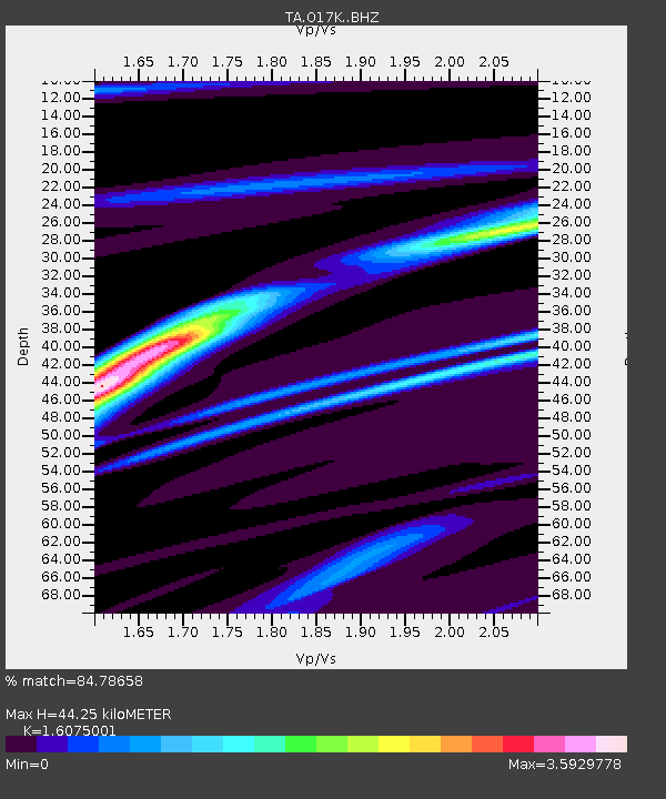
| Estimated Moho Depth: |
44.25 km |
| Estimated Crust Vp/Vs: |
1.61 |
| Assumed Crust Vp: |
6.276 km/s |
| Estimated Crust Vs: |
3.904 km/s |
| Estimated Crust Poisson's Ratio: |
0.18 |
|
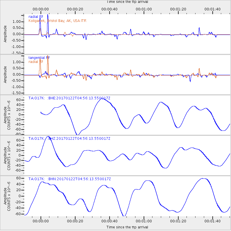
| Radial Match: |
84.78658 % |
| Radial Bump: |
307 |
| Transverse Match: |
65.93068 % |
| Transverse Bump: |
350 |
| SOD ConfigId: |
11737051 |
| Insert Time: |
2019-04-26 16:53:07.222 +0000 |
| GWidth: |
2.5 |
| Max Bumps: |
400 |
| Tol: |
0.001 |
|
Signal To Noise
| Channel | StoN | STA | LTA |
| TA:O17K: :BHZ:20170122T04:56:13.550017Z | 3.6156511 | 6.108805E-5 | 1.6895448E-5 |
| TA:O17K: :BHN:20170122T04:56:13.550017Z | 1.359803 | 5.543761E-5 | 4.0768853E-5 |
| TA:O17K: :BHE:20170122T04:56:13.550017Z | 1.1603385 | 4.6800284E-5 | 4.0333303E-5 |
| Arrivals |
| Ps | 4.4 SECOND |
| PpPs | 18 SECOND |
| PsPs/PpSs | 22 SECOND |


