You are here: Home > Network List > TA - USArray Transportable Network (new EarthScope stations) Stations List
> Station Q17K Contact Creek, Katmai, AK, USA > Earthquake Result Viewer
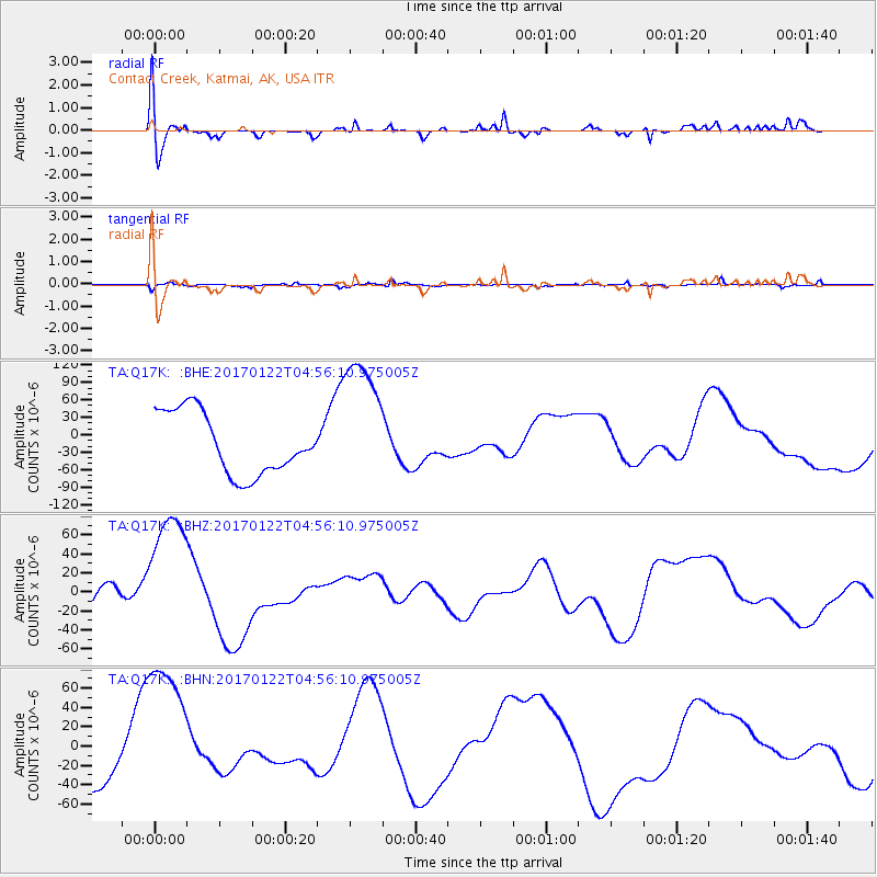
Q17K Contact Creek, Katmai, AK, USA - Earthquake Result Viewer
*The percent match for this event was below the threshold and hence no stack was calculated.
| Earthquake location: |
New Britain Region, P.N.G. |
| Earthquake latitude/longitude: |
-6.7/153.6 |
| Earthquake time(UTC): |
2017/01/22 (022) 04:44:52 GMT |
| Earthquake Depth: |
10 km |
| Earthquake Magnitude: |
5.6 mb |
| Earthquake Catalog/Contributor: |
NEIC PDE/us |
|
| Network: |
TA USArray Transportable Network (new EarthScope stations) |
| Station: |
Q17K Contact Creek, Katmai, AK, USA |
| Lat/Lon: |
58.26 N/155.89 W |
| Elevation: |
1165 m |
|
| Distance: |
76.4 deg |
| Az: |
24.822 deg |
| Baz: |
232.075 deg |
| Ray Param: |
$rayparam |
*The percent match for this event was below the threshold and hence was not used in the summary stack. |
|
| Radial Match: |
78.43843 % |
| Radial Bump: |
400 |
| Transverse Match: |
52.860832 % |
| Transverse Bump: |
322 |
| SOD ConfigId: |
11737051 |
| Insert Time: |
2019-04-26 16:53:12.639 +0000 |
| GWidth: |
2.5 |
| Max Bumps: |
400 |
| Tol: |
0.001 |
|
Signal To Noise
| Channel | StoN | STA | LTA |
| TA:Q17K: :BHZ:20170122T04:56:10.975005Z | 4.0098343 | 7.457886E-5 | 1.8598987E-5 |
| TA:Q17K: :BHN:20170122T04:56:10.975005Z | 2.078515 | 8.064819E-5 | 3.880087E-5 |
| TA:Q17K: :BHE:20170122T04:56:10.975005Z | 2.2490182 | 1.1795591E-4 | 5.2447733E-5 |
| Arrivals |
| Ps | |
| PpPs | |
| PsPs/PpSs | |


