You are here: Home > Network List > TA - USArray Transportable Network (new EarthScope stations) Stations List
> Station R31K City Hall, Gustavus, AK, USA > Earthquake Result Viewer
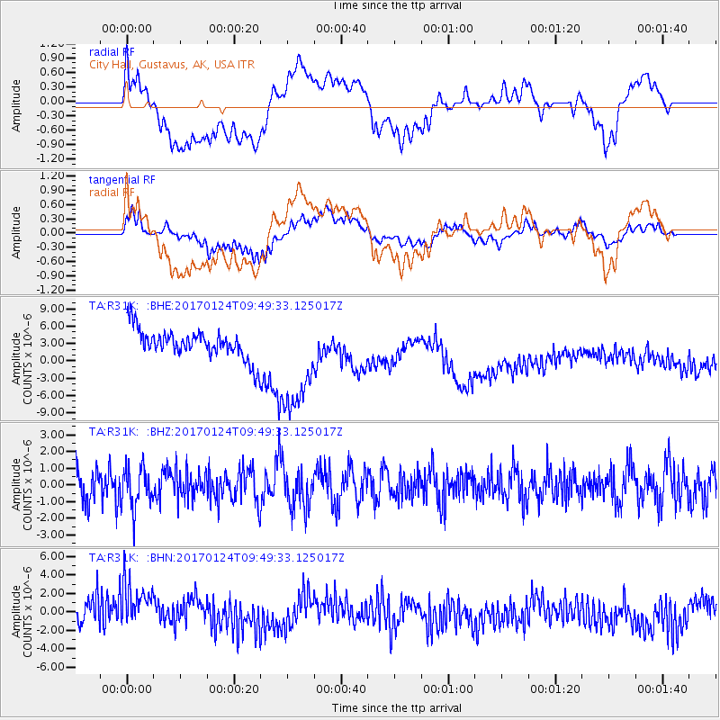
R31K City Hall, Gustavus, AK, USA - Earthquake Result Viewer
*The percent match for this event was below the threshold and hence no stack was calculated.
| Earthquake location: |
South Of Mariana Islands |
| Earthquake latitude/longitude: |
12.1/146.3 |
| Earthquake time(UTC): |
2017/01/24 (024) 09:38:32 GMT |
| Earthquake Depth: |
19 km |
| Earthquake Magnitude: |
5.5 mb |
| Earthquake Catalog/Contributor: |
NEIC PDE/us |
|
| Network: |
TA USArray Transportable Network (new EarthScope stations) |
| Station: |
R31K City Hall, Gustavus, AK, USA |
| Lat/Lon: |
58.41 N/135.74 W |
| Elevation: |
15 m |
|
| Distance: |
73.5 deg |
| Az: |
32.472 deg |
| Baz: |
266.192 deg |
| Ray Param: |
$rayparam |
*The percent match for this event was below the threshold and hence was not used in the summary stack. |
|
| Radial Match: |
22.64861 % |
| Radial Bump: |
400 |
| Transverse Match: |
34.51162 % |
| Transverse Bump: |
400 |
| SOD ConfigId: |
11737051 |
| Insert Time: |
2019-04-26 16:59:23.546 +0000 |
| GWidth: |
2.5 |
| Max Bumps: |
400 |
| Tol: |
0.001 |
|
Signal To Noise
| Channel | StoN | STA | LTA |
| TA:R31K: :BHZ:20170124T09:49:33.125017Z | 1.5181562 | 1.2069067E-6 | 7.94982E-7 |
| TA:R31K: :BHN:20170124T09:49:33.125017Z | 1.961159 | 2.9296393E-6 | 1.4938306E-6 |
| TA:R31K: :BHE:20170124T09:49:33.125017Z | 3.5991008 | 9.0489E-6 | 2.5142115E-6 |
| Arrivals |
| Ps | |
| PpPs | |
| PsPs/PpSs | |


