You are here: Home > Network List > CN - Canadian National Seismograph Network Stations List
> Station NLLB Nanaimo Lost Lake, BC, CA > Earthquake Result Viewer
NLLB Nanaimo Lost Lake, BC, CA - Earthquake Result Viewer
| Earthquake location: |
Near Coast Of Northern Peru |
| Earthquake latitude/longitude: |
-9.3/-78.9 |
| Earthquake time(UTC): |
2017/01/28 (028) 06:42:32 GMT |
| Earthquake Depth: |
46 km |
| Earthquake Magnitude: |
5.3 Mww |
| Earthquake Catalog/Contributor: |
NEIC PDE/us |
|
| Network: |
CN Canadian National Seismograph Network |
| Station: |
NLLB Nanaimo Lost Lake, BC, CA |
| Lat/Lon: |
49.23 N/123.99 W |
| Elevation: |
199 m |
|
| Distance: |
70.4 deg |
| Az: |
330.466 deg |
| Baz: |
132.085 deg |
| Ray Param: |
0.054917186 |
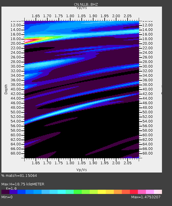
| Estimated Moho Depth: |
18.75 km |
| Estimated Crust Vp/Vs: |
1.60 |
| Assumed Crust Vp: |
6.566 km/s |
| Estimated Crust Vs: |
4.104 km/s |
| Estimated Crust Poisson's Ratio: |
0.18 |
|
| Radial Match: |
81.15064 % |
| Radial Bump: |
400 |
| Transverse Match: |
59.049942 % |
| Transverse Bump: |
400 |
| SOD ConfigId: |
11737051 |
| Insert Time: |
2019-04-26 17:04:24.861 +0000 |
| GWidth: |
2.5 |
| Max Bumps: |
400 |
| Tol: |
0.001 |
|

Signal To Noise
| Channel | StoN | STA | LTA |
| CN:NLLB: :BHZ:20170128T06:53:09.749983Z | 0.7162182 | 7.760978E-7 | 1.0836053E-6 |
| CN:NLLB: :BHN:20170128T06:53:09.749983Z | 1.787614 | 1.2018502E-6 | 6.723209E-7 |
| CN:NLLB: :BHE:20170128T06:53:09.749983Z | 0.8571223 | 6.8068164E-7 | 7.9414764E-7 |
| Arrivals |
| Ps | 1.8 SECOND |
| PpPs | 7.1 SECOND |
| PsPs/PpSs | 8.9 SECOND |


