You are here: Home > Network List > US - United States National Seismic Network Stations List
> Station HDIL Hopedale, Illinois, USA > Earthquake Result Viewer
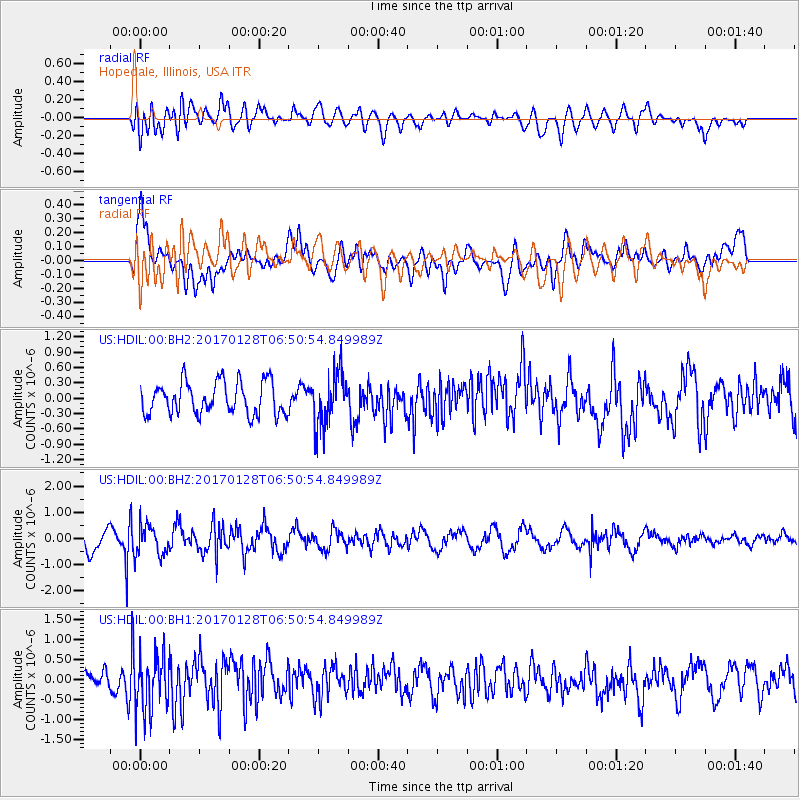
HDIL Hopedale, Illinois, USA - Earthquake Result Viewer
*The percent match for this event was below the threshold and hence no stack was calculated.
| Earthquake location: |
Near Coast Of Northern Peru |
| Earthquake latitude/longitude: |
-9.3/-78.9 |
| Earthquake time(UTC): |
2017/01/28 (028) 06:42:32 GMT |
| Earthquake Depth: |
46 km |
| Earthquake Magnitude: |
5.3 Mww |
| Earthquake Catalog/Contributor: |
NEIC PDE/us |
|
| Network: |
US United States National Seismic Network |
| Station: |
HDIL Hopedale, Illinois, USA |
| Lat/Lon: |
40.56 N/89.29 W |
| Elevation: |
219 m |
|
| Distance: |
50.5 deg |
| Az: |
349.729 deg |
| Baz: |
166.645 deg |
| Ray Param: |
$rayparam |
*The percent match for this event was below the threshold and hence was not used in the summary stack. |
|
| Radial Match: |
47.485992 % |
| Radial Bump: |
400 |
| Transverse Match: |
60.689163 % |
| Transverse Bump: |
400 |
| SOD ConfigId: |
11737051 |
| Insert Time: |
2019-04-26 17:09:34.133 +0000 |
| GWidth: |
2.5 |
| Max Bumps: |
400 |
| Tol: |
0.001 |
|
Signal To Noise
| Channel | StoN | STA | LTA |
| US:HDIL:00:BHZ:20170128T06:50:54.849989Z | 1.5639696 | 5.568252E-7 | 3.560333E-7 |
| US:HDIL:00:BH1:20170128T06:50:54.849989Z | 2.3760438 | 6.9940705E-7 | 2.9435782E-7 |
| US:HDIL:00:BH2:20170128T06:50:54.849989Z | 1.5759337 | 4.925082E-7 | 3.1251835E-7 |
| Arrivals |
| Ps | |
| PpPs | |
| PsPs/PpSs | |


