You are here: Home > Network List > AV - Alaska Volcano Observatory Stations List
> Station SPCR Ckakachatna River, Mount Spurr, Alaska > Earthquake Result Viewer
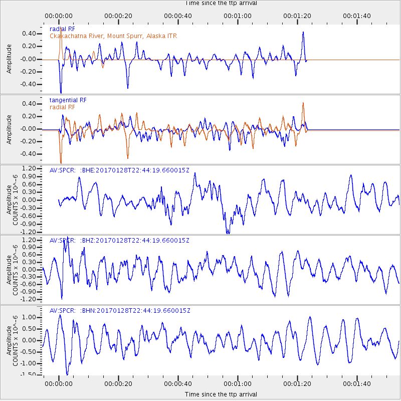
SPCR Ckakachatna River, Mount Spurr, Alaska - Earthquake Result Viewer
*The percent match for this event was below the threshold and hence no stack was calculated.
| Earthquake location: |
Samoa Islands Region |
| Earthquake latitude/longitude: |
-15.3/-173.0 |
| Earthquake time(UTC): |
2017/01/28 (028) 22:32:51 GMT |
| Earthquake Depth: |
10 km |
| Earthquake Magnitude: |
5.7 mb |
| Earthquake Catalog/Contributor: |
NEIC PDE/us |
|
| Network: |
AV Alaska Volcano Observatory |
| Station: |
SPCR Ckakachatna River, Mount Spurr, Alaska |
| Lat/Lon: |
61.20 N/152.21 W |
| Elevation: |
984 m |
|
| Distance: |
78.0 deg |
| Az: |
10.106 deg |
| Baz: |
200.467 deg |
| Ray Param: |
$rayparam |
*The percent match for this event was below the threshold and hence was not used in the summary stack. |
|
| Radial Match: |
66.34813 % |
| Radial Bump: |
366 |
| Transverse Match: |
55.417503 % |
| Transverse Bump: |
349 |
| SOD ConfigId: |
11737051 |
| Insert Time: |
2019-04-26 17:13:47.010 +0000 |
| GWidth: |
2.5 |
| Max Bumps: |
400 |
| Tol: |
0.001 |
|
Signal To Noise
| Channel | StoN | STA | LTA |
| AV:SPCR: :BHZ:20170128T22:44:19.660015Z | 1.9006178 | 7.239369E-7 | 3.8089556E-7 |
| AV:SPCR: :BHN:20170128T22:44:19.660015Z | 2.059507 | 8.4818674E-7 | 4.1183972E-7 |
| AV:SPCR: :BHE:20170128T22:44:19.660015Z | 0.6440187 | 2.011255E-7 | 3.122976E-7 |
| Arrivals |
| Ps | |
| PpPs | |
| PsPs/PpSs | |


