You are here: Home > Network List > AU - Australian Seismological Centre Stations List
> Station CTA Charters Towers, Queensland > Earthquake Result Viewer
CTA Charters Towers, Queensland - Earthquake Result Viewer
| Earthquake location: |
Kermadec Islands, New Zealand |
| Earthquake latitude/longitude: |
-30.1/-177.5 |
| Earthquake time(UTC): |
2017/01/29 (029) 14:59:51 GMT |
| Earthquake Depth: |
14 km |
| Earthquake Magnitude: |
5.7 Mwb |
| Earthquake Catalog/Contributor: |
NEIC PDE/us |
|
| Network: |
AU Australian Seismological Centre |
| Station: |
CTA Charters Towers, Queensland |
| Lat/Lon: |
20.09 S/146.25 E |
| Elevation: |
426 m |
|
| Distance: |
34.2 deg |
| Az: |
278.418 deg |
| Baz: |
114.207 deg |
| Ray Param: |
0.077850245 |
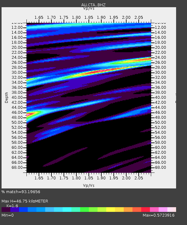
| Estimated Moho Depth: |
46.75 km |
| Estimated Crust Vp/Vs: |
1.60 |
| Assumed Crust Vp: |
6.522 km/s |
| Estimated Crust Vs: |
4.076 km/s |
| Estimated Crust Poisson's Ratio: |
0.18 |
|
| Radial Match: |
93.19656 % |
| Radial Bump: |
244 |
| Transverse Match: |
64.14081 % |
| Transverse Bump: |
400 |
| SOD ConfigId: |
11737051 |
| Insert Time: |
2019-04-26 17:23:44.365 +0000 |
| GWidth: |
2.5 |
| Max Bumps: |
400 |
| Tol: |
0.001 |
|

Signal To Noise
| Channel | StoN | STA | LTA |
| AU:CTA: :BHZ:20170129T15:06:05.825Z | 9.050709 | 1.4652545E-6 | 1.618939E-7 |
| AU:CTA: :BHN:20170129T15:06:05.825Z | 2.1358743 | 2.8101326E-7 | 1.3156826E-7 |
| AU:CTA: :BHE:20170129T15:06:05.825Z | 10.8061905 | 9.481117E-7 | 8.773783E-8 |
| Arrivals |
| Ps | 4.7 SECOND |
| PpPs | 17 SECOND |
| PsPs/PpSs | 22 SECOND |


