You are here: Home > Network List > IU - Global Seismograph Network (GSN - IRIS/USGS) Stations List
> Station PMG Port Moresby, New Guinea > Earthquake Result Viewer
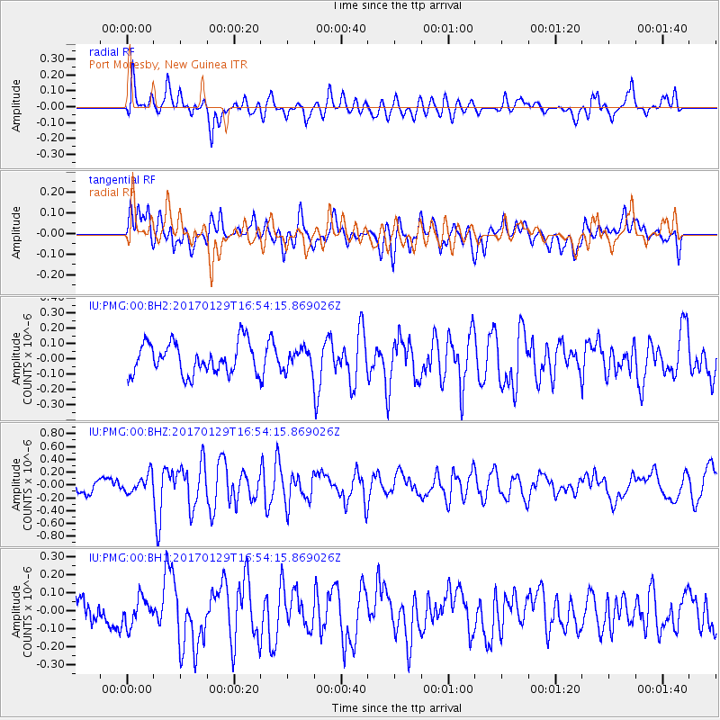
PMG Port Moresby, New Guinea - Earthquake Result Viewer
*The percent match for this event was below the threshold and hence no stack was calculated.
| Earthquake location: |
Southwest Indian Ridge |
| Earthquake latitude/longitude: |
-29.2/61.1 |
| Earthquake time(UTC): |
2017/01/29 (029) 16:42:26 GMT |
| Earthquake Depth: |
10 km |
| Earthquake Magnitude: |
5.8 mb |
| Earthquake Catalog/Contributor: |
NEIC PDE/us |
|
| Network: |
IU Global Seismograph Network (GSN - IRIS/USGS) |
| Station: |
PMG Port Moresby, New Guinea |
| Lat/Lon: |
9.40 S/147.16 E |
| Elevation: |
90 m |
|
| Distance: |
82.0 deg |
| Az: |
96.299 deg |
| Baz: |
241.697 deg |
| Ray Param: |
$rayparam |
*The percent match for this event was below the threshold and hence was not used in the summary stack. |
|
| Radial Match: |
49.30988 % |
| Radial Bump: |
400 |
| Transverse Match: |
61.114395 % |
| Transverse Bump: |
400 |
| SOD ConfigId: |
11737051 |
| Insert Time: |
2019-04-26 17:34:21.148 +0000 |
| GWidth: |
2.5 |
| Max Bumps: |
400 |
| Tol: |
0.001 |
|
Signal To Noise
| Channel | StoN | STA | LTA |
| IU:PMG:00:BHZ:20170129T16:54:15.869026Z | 1.2564194 | 1.4088793E-7 | 1.1213448E-7 |
| IU:PMG:00:BH1:20170129T16:54:15.869026Z | 1.005015 | 7.684707E-8 | 7.6463614E-8 |
| IU:PMG:00:BH2:20170129T16:54:15.869026Z | 0.6202514 | 6.240475E-8 | 1.0061203E-7 |
| Arrivals |
| Ps | |
| PpPs | |
| PsPs/PpSs | |


