You are here: Home > Network List > CI - Caltech Regional Seismic Network Stations List
> Station FMP Fort MacArthur Park, Pt. Fermin San Pedro, CA, USA > Earthquake Result Viewer
FMP Fort MacArthur Park, Pt. Fermin San Pedro, CA, USA - Earthquake Result Viewer
| Earthquake location: |
Sea Of Okhotsk |
| Earthquake latitude/longitude: |
53.9/152.9 |
| Earthquake time(UTC): |
2008/07/05 (187) 02:12:04 GMT |
| Earthquake Depth: |
633 km |
| Earthquake Magnitude: |
6.8 MB, 7.7 MW, 7.7 MW |
| Earthquake Catalog/Contributor: |
WHDF/NEIC |
|
| Network: |
CI Caltech Regional Seismic Network |
| Station: |
FMP Fort MacArthur Park, Pt. Fermin San Pedro, CA, USA |
| Lat/Lon: |
33.71 N/118.29 W |
| Elevation: |
89 m |
|
| Distance: |
62.9 deg |
| Az: |
69.4 deg |
| Baz: |
318.33 deg |
| Ray Param: |
0.057438027 |
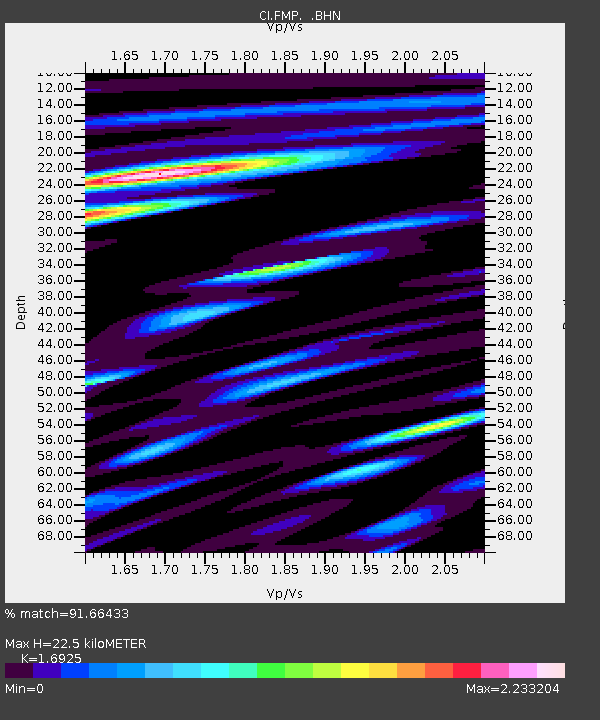
| Estimated Moho Depth: |
22.5 km |
| Estimated Crust Vp/Vs: |
1.69 |
| Assumed Crust Vp: |
6.048 km/s |
| Estimated Crust Vs: |
3.573 km/s |
| Estimated Crust Poisson's Ratio: |
0.23 |
|
| Radial Match: |
91.66433 % |
| Radial Bump: |
400 |
| Transverse Match: |
88.993065 % |
| Transverse Bump: |
400 |
| SOD ConfigId: |
2504 |
| Insert Time: |
2010-03-05 21:51:33.504 +0000 |
| GWidth: |
2.5 |
| Max Bumps: |
400 |
| Tol: |
0.001 |
|
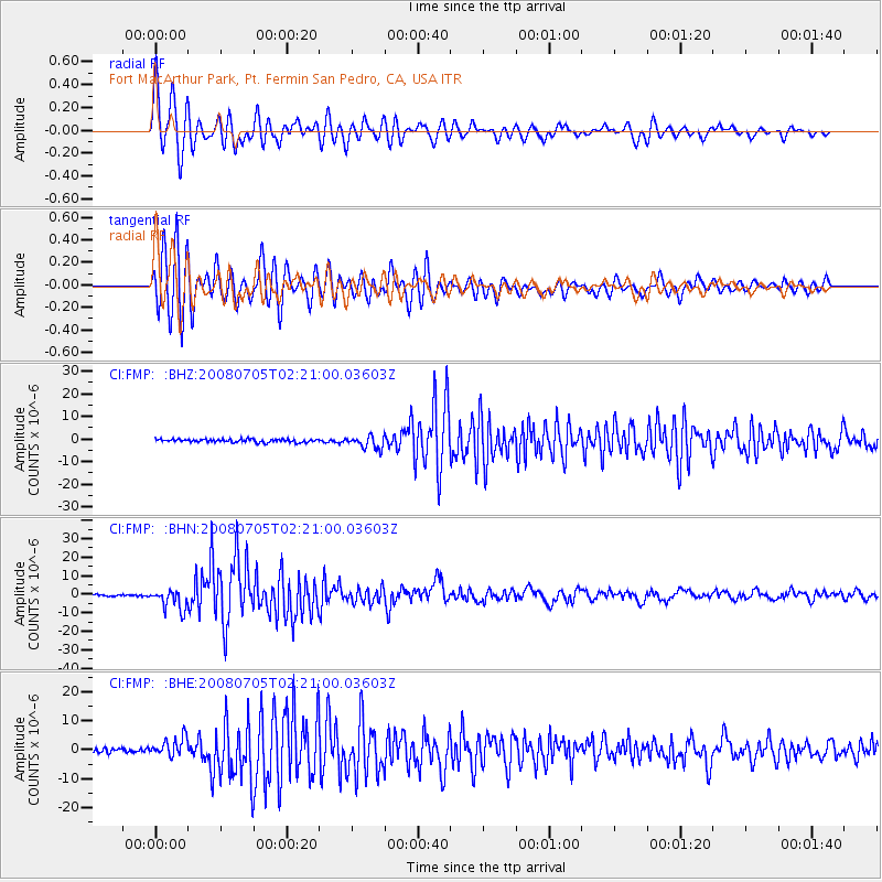
Signal To Noise
| Channel | StoN | STA | LTA |
| CI:FMP: :BHN:20080705T02:21:00.03603Z | 16.027224 | 5.5605256E-6 | 3.4694256E-7 |
| CI:FMP: :BHE:20080705T02:21:00.03603Z | 5.337449 | 3.2715066E-6 | 6.1293446E-7 |
| CI:FMP: :BHZ:20080705T02:21:00.03603Z | 4.145684 | 2.8105178E-6 | 6.779383E-7 |
| Arrivals |
| Ps | 2.7 SECOND |
| PpPs | 9.7 SECOND |
| PsPs/PpSs | 12 SECOND |


