You are here: Home > Network List > CI - Caltech Regional Seismic Network Stations List
> Station FMP Fort MacArthur Park, Pt. Fermin San Pedro, CA, USA > Earthquake Result Viewer
FMP Fort MacArthur Park, Pt. Fermin San Pedro, CA, USA - Earthquake Result Viewer
| Earthquake location: |
Solomon Islands |
| Earthquake latitude/longitude: |
-10.9/162.1 |
| Earthquake time(UTC): |
2007/11/27 (331) 11:49:58 GMT |
| Earthquake Depth: |
16 km |
| Earthquake Magnitude: |
5.9 MB, 6.7 MS, 6.6 MW, 6.4 MW |
| Earthquake Catalog/Contributor: |
WHDF/NEIC |
|
| Network: |
CI Caltech Regional Seismic Network |
| Station: |
FMP Fort MacArthur Park, Pt. Fermin San Pedro, CA, USA |
| Lat/Lon: |
33.71 N/118.29 W |
| Elevation: |
89 m |
|
| Distance: |
87.5 deg |
| Az: |
55.139 deg |
| Baz: |
255.173 deg |
| Ray Param: |
0.043291762 |
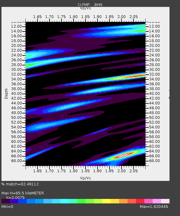
| Estimated Moho Depth: |
65.5 km |
| Estimated Crust Vp/Vs: |
2.01 |
| Assumed Crust Vp: |
6.048 km/s |
| Estimated Crust Vs: |
3.013 km/s |
| Estimated Crust Poisson's Ratio: |
0.33 |
|
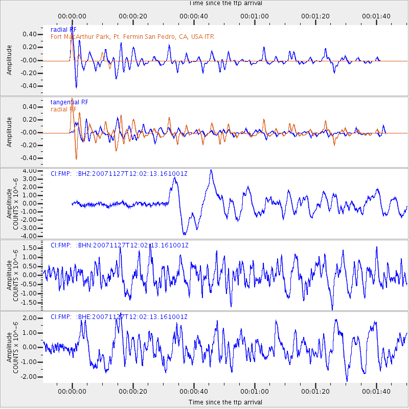
| Radial Match: |
82.49112 % |
| Radial Bump: |
400 |
| Transverse Match: |
76.1568 % |
| Transverse Bump: |
400 |
| SOD ConfigId: |
2564 |
| Insert Time: |
2010-03-05 21:51:53.026 +0000 |
| GWidth: |
2.5 |
| Max Bumps: |
400 |
| Tol: |
0.001 |
|
Signal To Noise
| Channel | StoN | STA | LTA |
| CI:FMP: :BHN:20071127T12:02:13.161001Z | 0.8850559 | 2.9996502E-7 | 3.389221E-7 |
| CI:FMP: :BHE:20071127T12:02:13.161001Z | 3.2655659 | 8.8348855E-7 | 2.7054685E-7 |
| CI:FMP: :BHZ:20071127T12:02:13.161001Z | 9.753577 | 1.7394361E-6 | 1.7833827E-7 |
| Arrivals |
| Ps | 11 SECOND |
| PpPs | 32 SECOND |
| PsPs/PpSs | 43 SECOND |


