You are here: Home > Network List > TA - USArray Transportable Network (new EarthScope stations) Stations List
> Station G21K Allakaket, AK, USA > Earthquake Result Viewer
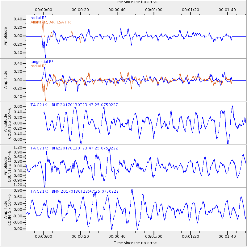
G21K Allakaket, AK, USA - Earthquake Result Viewer
*The percent match for this event was below the threshold and hence no stack was calculated.
| Earthquake location: |
Vanuatu Islands |
| Earthquake latitude/longitude: |
-14.8/167.2 |
| Earthquake time(UTC): |
2017/01/30 (030) 23:35:23 GMT |
| Earthquake Depth: |
78 km |
| Earthquake Magnitude: |
5.8 Mwp |
| Earthquake Catalog/Contributor: |
NEIC PDE/us |
|
| Network: |
TA USArray Transportable Network (new EarthScope stations) |
| Station: |
G21K Allakaket, AK, USA |
| Lat/Lon: |
66.52 N/153.51 W |
| Elevation: |
446 m |
|
| Distance: |
86.1 deg |
| Az: |
14.75 deg |
| Baz: |
217.917 deg |
| Ray Param: |
$rayparam |
*The percent match for this event was below the threshold and hence was not used in the summary stack. |
|
| Radial Match: |
69.968735 % |
| Radial Bump: |
399 |
| Transverse Match: |
61.770428 % |
| Transverse Bump: |
400 |
| SOD ConfigId: |
11737051 |
| Insert Time: |
2019-04-26 17:41:11.624 +0000 |
| GWidth: |
2.5 |
| Max Bumps: |
400 |
| Tol: |
0.001 |
|
Signal To Noise
| Channel | StoN | STA | LTA |
| TA:G21K: :BHZ:20170130T23:47:25.075022Z | 2.321062 | 6.1176297E-7 | 2.6357026E-7 |
| TA:G21K: :BHN:20170130T23:47:25.075022Z | 1.0192844 | 2.4713995E-7 | 2.4246418E-7 |
| TA:G21K: :BHE:20170130T23:47:25.075022Z | 0.88363504 | 2.9562432E-7 | 3.3455478E-7 |
| Arrivals |
| Ps | |
| PpPs | |
| PsPs/PpSs | |


