You are here: Home > Network List > CI - Caltech Regional Seismic Network Stations List
> Station FMP Fort MacArthur Park, Pt. Fermin San Pedro, CA, USA > Earthquake Result Viewer
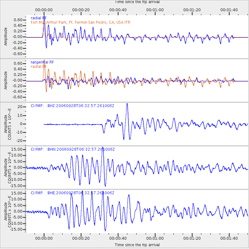
FMP Fort MacArthur Park, Pt. Fermin San Pedro, CA, USA - Earthquake Result Viewer
| Earthquake location: |
Samoa Islands Region |
| Earthquake latitude/longitude: |
-16.6/-172.0 |
| Earthquake time(UTC): |
2006/09/28 (271) 06:22:09 GMT |
| Earthquake Depth: |
28 km |
| Earthquake Magnitude: |
6.5 MB, 6.6 MS, 6.9 MW, 6.7 MW |
| Earthquake Catalog/Contributor: |
WHDF/NEIC |
|
| Network: |
CI Caltech Regional Seismic Network |
| Station: |
FMP Fort MacArthur Park, Pt. Fermin San Pedro, CA, USA |
| Lat/Lon: |
33.71 N/118.29 W |
| Elevation: |
89 m |
|
| Distance: |
71.6 deg |
| Az: |
45.105 deg |
| Baz: |
234.58 deg |
| Ray Param: |
0.05419419 |
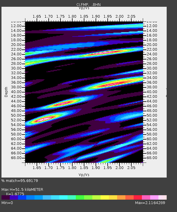
| Estimated Moho Depth: |
51.5 km |
| Estimated Crust Vp/Vs: |
1.68 |
| Assumed Crust Vp: |
6.048 km/s |
| Estimated Crust Vs: |
3.605 km/s |
| Estimated Crust Poisson's Ratio: |
0.22 |
|
| Radial Match: |
95.69179 % |
| Radial Bump: |
400 |
| Transverse Match: |
90.7216 % |
| Transverse Bump: |
400 |
| SOD ConfigId: |
2665 |
| Insert Time: |
2010-03-05 21:52:46.552 +0000 |
| GWidth: |
2.5 |
| Max Bumps: |
400 |
| Tol: |
0.001 |
|
Signal To Noise
| Channel | StoN | STA | LTA |
| CI:FMP: :BHN:20060928T06:32:57.261006Z | 2.9375024 | 1.3787309E-6 | 4.6935477E-7 |
| CI:FMP: :BHE:20060928T06:32:57.261006Z | 5.3663692 | 2.3018924E-6 | 4.2894783E-7 |
| CI:FMP: :BHZ:20060928T06:32:57.261006Z | 19.185318 | 4.1438257E-6 | 2.159894E-7 |
| Arrivals |
| Ps | 6.0 SECOND |
| PpPs | 22 SECOND |
| PsPs/PpSs | 28 SECOND |


