You are here: Home > Network List > CI - Caltech Regional Seismic Network Stations List
> Station FMP Fort MacArthur Park, Pt. Fermin San Pedro, CA, USA > Earthquake Result Viewer
FMP Fort MacArthur Park, Pt. Fermin San Pedro, CA, USA - Earthquake Result Viewer
| Earthquake location: |
Eastern Siberia, Russia |
| Earthquake latitude/longitude: |
60.9/167.1 |
| Earthquake time(UTC): |
2006/04/20 (110) 23:25:02 GMT |
| Earthquake Depth: |
22 km |
| Earthquake Magnitude: |
6.8 MB, 7.6 MS, 7.6 MW, 7.3 MW |
| Earthquake Catalog/Contributor: |
WHDF/NEIC |
|
| Network: |
CI Caltech Regional Seismic Network |
| Station: |
FMP Fort MacArthur Park, Pt. Fermin San Pedro, CA, USA |
| Lat/Lon: |
33.71 N/118.29 W |
| Elevation: |
89 m |
|
| Distance: |
53.8 deg |
| Az: |
84.552 deg |
| Baz: |
324.345 deg |
| Ray Param: |
0.06580229 |
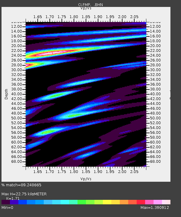
| Estimated Moho Depth: |
22.75 km |
| Estimated Crust Vp/Vs: |
1.71 |
| Assumed Crust Vp: |
6.048 km/s |
| Estimated Crust Vs: |
3.537 km/s |
| Estimated Crust Poisson's Ratio: |
0.24 |
|
| Radial Match: |
89.248665 % |
| Radial Bump: |
400 |
| Transverse Match: |
84.80596 % |
| Transverse Bump: |
400 |
| SOD ConfigId: |
2669 |
| Insert Time: |
2010-03-05 21:52:58.316 +0000 |
| GWidth: |
2.5 |
| Max Bumps: |
400 |
| Tol: |
0.001 |
|
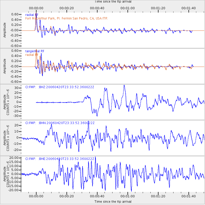
Signal To Noise
| Channel | StoN | STA | LTA |
| CI:FMP: :BHN:20060420T23:33:52.360022Z | 6.6124463 | 4.4381623E-6 | 6.7118305E-7 |
| CI:FMP: :BHE:20060420T23:33:52.360022Z | 4.4073067 | 3.2857838E-6 | 7.4553105E-7 |
| CI:FMP: :BHZ:20060420T23:33:52.360022Z | 23.836071 | 8.350628E-6 | 3.5033577E-7 |
| Arrivals |
| Ps | 2.8 SECOND |
| PpPs | 9.7 SECOND |
| PsPs/PpSs | 13 SECOND |


