You are here: Home > Network List > CI - Caltech Regional Seismic Network Stations List
> Station FMP Fort MacArthur Park, Pt. Fermin San Pedro, CA, USA > Earthquake Result Viewer
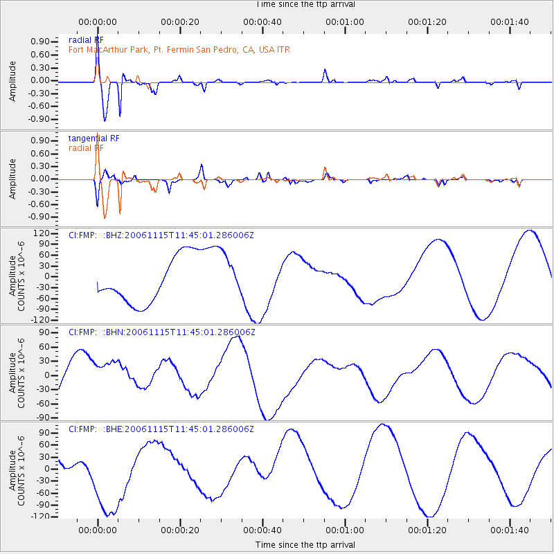
FMP Fort MacArthur Park, Pt. Fermin San Pedro, CA, USA - Earthquake Result Viewer
| Earthquake location: |
East Of Kuril Islands |
| Earthquake latitude/longitude: |
46.7/155.3 |
| Earthquake time(UTC): |
2006/11/15 (319) 11:34:58 GMT |
| Earthquake Depth: |
10 km |
| Earthquake Magnitude: |
6.4 MB |
| Earthquake Catalog/Contributor: |
WHDF/NEIC |
|
| Network: |
CI Caltech Regional Seismic Network |
| Station: |
FMP Fort MacArthur Park, Pt. Fermin San Pedro, CA, USA |
| Lat/Lon: |
33.71 N/118.29 W |
| Elevation: |
89 m |
|
| Distance: |
64.1 deg |
| Az: |
67.615 deg |
| Baz: |
310.169 deg |
| Ray Param: |
0.059129562 |
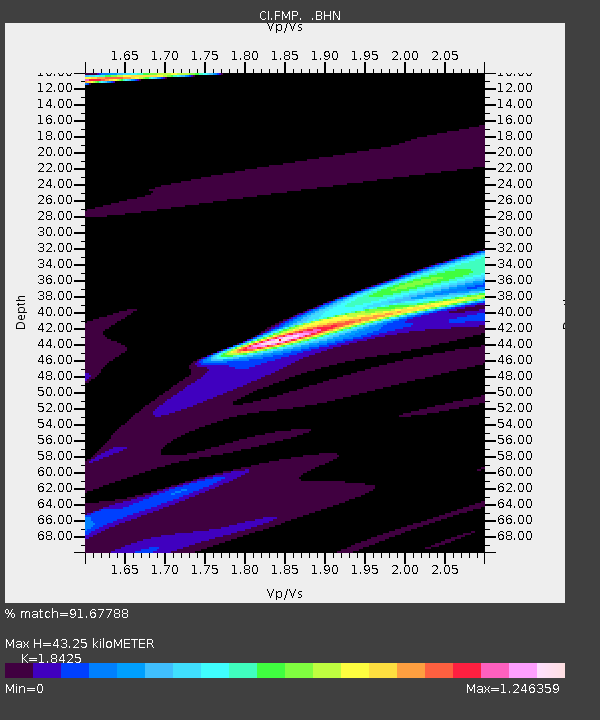
| Estimated Moho Depth: |
43.25 km |
| Estimated Crust Vp/Vs: |
1.84 |
| Assumed Crust Vp: |
6.048 km/s |
| Estimated Crust Vs: |
3.282 km/s |
| Estimated Crust Poisson's Ratio: |
0.29 |
|
| Radial Match: |
91.67788 % |
| Radial Bump: |
400 |
| Transverse Match: |
69.33466 % |
| Transverse Bump: |
400 |
| SOD ConfigId: |
2564 |
| Insert Time: |
2010-03-05 21:53:09.305 +0000 |
| GWidth: |
2.5 |
| Max Bumps: |
400 |
| Tol: |
0.001 |
|
Signal To Noise
| Channel | StoN | STA | LTA |
| CI:FMP: :BHN:20061115T11:45:01.286006Z | 0.5230099 | 3.401964E-5 | 6.5045875E-5 |
| CI:FMP: :BHE:20061115T11:45:01.286006Z | 2.7645674 | 1.08918764E-4 | 3.9398124E-5 |
| CI:FMP: :BHZ:20061115T11:45:01.286006Z | 1.0210334 | 6.439014E-5 | 6.30637E-5 |
| Arrivals |
| Ps | 6.2 SECOND |
| PpPs | 20 SECOND |
| PsPs/PpSs | 26 SECOND |


