You are here: Home > Network List > IU - Global Seismograph Network (GSN - IRIS/USGS) Stations List
> Station MAKZ Makanchi, Kazakhstan > Earthquake Result Viewer
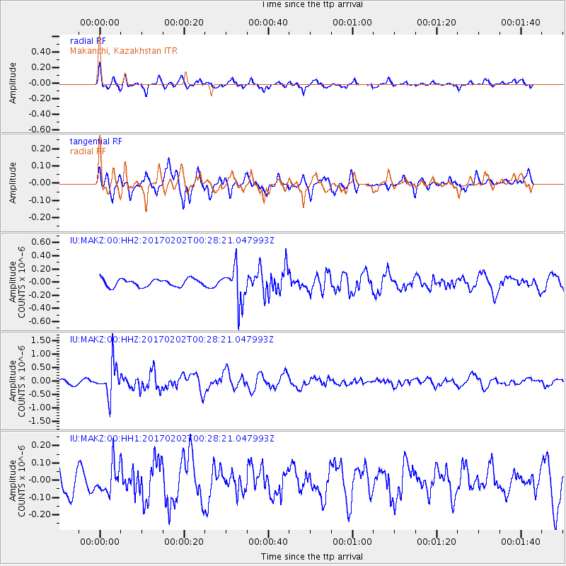
MAKZ Makanchi, Kazakhstan - Earthquake Result Viewer
*The percent match for this event was below the threshold and hence no stack was calculated.
| Earthquake location: |
South Of Mariana Islands |
| Earthquake latitude/longitude: |
12.1/141.0 |
| Earthquake time(UTC): |
2017/02/02 (033) 00:18:43 GMT |
| Earthquake Depth: |
9.0 km |
| Earthquake Magnitude: |
5.6 Mww |
| Earthquake Catalog/Contributor: |
NEIC PDE/us |
|
| Network: |
IU Global Seismograph Network (GSN - IRIS/USGS) |
| Station: |
MAKZ Makanchi, Kazakhstan |
| Lat/Lon: |
46.81 N/81.98 E |
| Elevation: |
600 m |
|
| Distance: |
60.2 deg |
| Az: |
317.252 deg |
| Baz: |
104.869 deg |
| Ray Param: |
$rayparam |
*The percent match for this event was below the threshold and hence was not used in the summary stack. |
|
| Radial Match: |
61.466736 % |
| Radial Bump: |
377 |
| Transverse Match: |
78.81986 % |
| Transverse Bump: |
400 |
| SOD ConfigId: |
11737051 |
| Insert Time: |
2019-04-26 17:56:49.087 +0000 |
| GWidth: |
2.5 |
| Max Bumps: |
400 |
| Tol: |
0.001 |
|
Signal To Noise
| Channel | StoN | STA | LTA |
| IU:MAKZ:00:HHZ:20170202T00:28:21.047993Z | 5.402964 | 6.0225716E-7 | 1.1146791E-7 |
| IU:MAKZ:00:HH1:20170202T00:28:21.047993Z | 1.2463273 | 8.1972644E-8 | 6.577136E-8 |
| IU:MAKZ:00:HH2:20170202T00:28:21.047993Z | 4.8793573 | 2.759671E-7 | 5.6558083E-8 |
| Arrivals |
| Ps | |
| PpPs | |
| PsPs/PpSs | |


