You are here: Home > Network List > TA - USArray Transportable Network (new EarthScope stations) Stations List
> Station F24K Squaw Lake, AK, USA > Earthquake Result Viewer
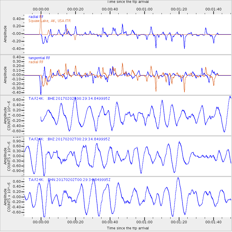
F24K Squaw Lake, AK, USA - Earthquake Result Viewer
*The percent match for this event was below the threshold and hence no stack was calculated.
| Earthquake location: |
South Of Mariana Islands |
| Earthquake latitude/longitude: |
12.1/141.0 |
| Earthquake time(UTC): |
2017/02/02 (033) 00:18:43 GMT |
| Earthquake Depth: |
9.0 km |
| Earthquake Magnitude: |
5.6 Mww |
| Earthquake Catalog/Contributor: |
NEIC PDE/us |
|
| Network: |
TA USArray Transportable Network (new EarthScope stations) |
| Station: |
F24K Squaw Lake, AK, USA |
| Lat/Lon: |
67.52 N/147.89 W |
| Elevation: |
736 m |
|
| Distance: |
71.7 deg |
| Az: |
22.534 deg |
| Baz: |
257.074 deg |
| Ray Param: |
$rayparam |
*The percent match for this event was below the threshold and hence was not used in the summary stack. |
|
| Radial Match: |
67.83707 % |
| Radial Bump: |
400 |
| Transverse Match: |
73.637695 % |
| Transverse Bump: |
400 |
| SOD ConfigId: |
11737051 |
| Insert Time: |
2019-04-26 17:58:09.949 +0000 |
| GWidth: |
2.5 |
| Max Bumps: |
400 |
| Tol: |
0.001 |
|
Signal To Noise
| Channel | StoN | STA | LTA |
| TA:F24K: :BHZ:20170202T00:29:34.849995Z | 1.8336921 | 6.833562E-7 | 3.7266682E-7 |
| TA:F24K: :BHN:20170202T00:29:34.849995Z | 1.5988065 | 5.0296336E-7 | 3.1458677E-7 |
| TA:F24K: :BHE:20170202T00:29:34.849995Z | 0.93253595 | 2.803588E-7 | 3.006413E-7 |
| Arrivals |
| Ps | |
| PpPs | |
| PsPs/PpSs | |


