You are here: Home > Network List > UW - Pacific Northwest Regional Seismic Network Stations List
> Station LEBA Lebam, WA, USA > Earthquake Result Viewer
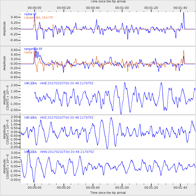
LEBA Lebam, WA, USA - Earthquake Result Viewer
*The percent match for this event was below the threshold and hence no stack was calculated.
| Earthquake location: |
South Of Mariana Islands |
| Earthquake latitude/longitude: |
12.1/141.0 |
| Earthquake time(UTC): |
2017/02/02 (033) 00:18:43 GMT |
| Earthquake Depth: |
9.0 km |
| Earthquake Magnitude: |
5.6 Mww |
| Earthquake Catalog/Contributor: |
NEIC PDE/us |
|
| Network: |
UW Pacific Northwest Regional Seismic Network |
| Station: |
LEBA Lebam, WA, USA |
| Lat/Lon: |
46.55 N/123.56 W |
| Elevation: |
73 m |
|
| Distance: |
85.0 deg |
| Az: |
43.608 deg |
| Baz: |
282.206 deg |
| Ray Param: |
$rayparam |
*The percent match for this event was below the threshold and hence was not used in the summary stack. |
|
| Radial Match: |
57.175426 % |
| Radial Bump: |
400 |
| Transverse Match: |
50.00148 % |
| Transverse Bump: |
400 |
| SOD ConfigId: |
11737051 |
| Insert Time: |
2019-04-26 17:58:58.706 +0000 |
| GWidth: |
2.5 |
| Max Bumps: |
400 |
| Tol: |
0.001 |
|
Signal To Noise
| Channel | StoN | STA | LTA |
| UW:LEBA: :HHZ:20170202T00:30:48.217976Z | 1.9764881 | 1.062455E-6 | 5.3754684E-7 |
| UW:LEBA: :HHN:20170202T00:30:48.217976Z | 1.7449114 | 1.7980732E-6 | 1.0304667E-6 |
| UW:LEBA: :HHE:20170202T00:30:48.217976Z | 1.1773133 | 7.1804726E-7 | 6.099033E-7 |
| Arrivals |
| Ps | |
| PpPs | |
| PsPs/PpSs | |


