You are here: Home > Network List > CI - Caltech Regional Seismic Network Stations List
> Station FMP Fort MacArthur Park, Pt. Fermin San Pedro, CA, USA > Earthquake Result Viewer
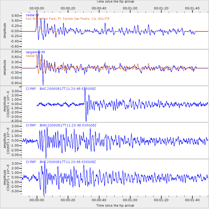
FMP Fort MacArthur Park, Pt. Fermin San Pedro, CA, USA - Earthquake Result Viewer
*The percent match for this event was below the threshold and hence no stack was calculated.
| Earthquake location: |
Near East Coast Of Kamchatka |
| Earthquake latitude/longitude: |
55.6/161.7 |
| Earthquake time(UTC): |
2006/08/17 (229) 11:11:35 GMT |
| Earthquake Depth: |
55 km |
| Earthquake Magnitude: |
6.1 MB, 5.7 MW, 5.7 MW |
| Earthquake Catalog/Contributor: |
WHDF/NEIC |
|
| Network: |
CI Caltech Regional Seismic Network |
| Station: |
FMP Fort MacArthur Park, Pt. Fermin San Pedro, CA, USA |
| Lat/Lon: |
33.71 N/118.29 W |
| Elevation: |
89 m |
|
| Distance: |
57.5 deg |
| Az: |
76.674 deg |
| Baz: |
318.527 deg |
| Ray Param: |
$rayparam |
*The percent match for this event was below the threshold and hence was not used in the summary stack. |
|
| Radial Match: |
84.9968 % |
| Radial Bump: |
400 |
| Transverse Match: |
88.54235 % |
| Transverse Bump: |
400 |
| SOD ConfigId: |
2564 |
| Insert Time: |
2010-03-05 21:54:27.868 +0000 |
| GWidth: |
2.5 |
| Max Bumps: |
400 |
| Tol: |
0.001 |
|
Signal To Noise
| Channel | StoN | STA | LTA |
| CI:FMP: :BHN:20060817T11:20:48.636008Z | 3.6006718 | 1.1622766E-6 | 3.2279436E-7 |
| CI:FMP: :BHE:20060817T11:20:48.636008Z | 5.4573436 | 1.4970386E-6 | 2.7431636E-7 |
| CI:FMP: :BHZ:20060817T11:20:48.636008Z | 7.9871855 | 1.667831E-6 | 2.0881335E-7 |
| Arrivals |
| Ps | |
| PpPs | |
| PsPs/PpSs | |


