You are here: Home > Network List > CI - Caltech Regional Seismic Network Stations List
> Station FMP Fort MacArthur Park, Pt. Fermin San Pedro, CA, USA > Earthquake Result Viewer
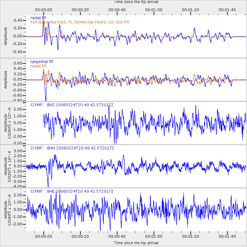
FMP Fort MacArthur Park, Pt. Fermin San Pedro, CA, USA - Earthquake Result Viewer
*The percent match for this event was below the threshold and hence no stack was calculated.
| Earthquake location: |
Chile-Bolivia Border Region |
| Earthquake latitude/longitude: |
-20.0/-69.0 |
| Earthquake time(UTC): |
2008/03/24 (084) 20:39:07 GMT |
| Earthquake Depth: |
120 km |
| Earthquake Magnitude: |
5.7 MB, 6.2 MW, 6.1 MW |
| Earthquake Catalog/Contributor: |
WHDF/NEIC |
|
| Network: |
CI Caltech Regional Seismic Network |
| Station: |
FMP Fort MacArthur Park, Pt. Fermin San Pedro, CA, USA |
| Lat/Lon: |
33.71 N/118.29 W |
| Elevation: |
89 m |
|
| Distance: |
71.2 deg |
| Az: |
318.093 deg |
| Baz: |
131.118 deg |
| Ray Param: |
$rayparam |
*The percent match for this event was below the threshold and hence was not used in the summary stack. |
|
| Radial Match: |
55.551353 % |
| Radial Bump: |
400 |
| Transverse Match: |
76.37158 % |
| Transverse Bump: |
400 |
| SOD ConfigId: |
2504 |
| Insert Time: |
2010-03-05 21:55:05.660 +0000 |
| GWidth: |
2.5 |
| Max Bumps: |
400 |
| Tol: |
0.001 |
|
Signal To Noise
| Channel | StoN | STA | LTA |
| CI:FMP: :BHN:20080324T20:49:42.572017Z | 4.325065 | 1.3610294E-6 | 3.1468414E-7 |
| CI:FMP: :BHE:20080324T20:49:42.572017Z | 1.5938176 | 1.0331057E-6 | 6.4819574E-7 |
| CI:FMP: :BHZ:20080324T20:49:42.572017Z | 0.66436327 | 5.387874E-7 | 8.109831E-7 |
| Arrivals |
| Ps | |
| PpPs | |
| PsPs/PpSs | |


