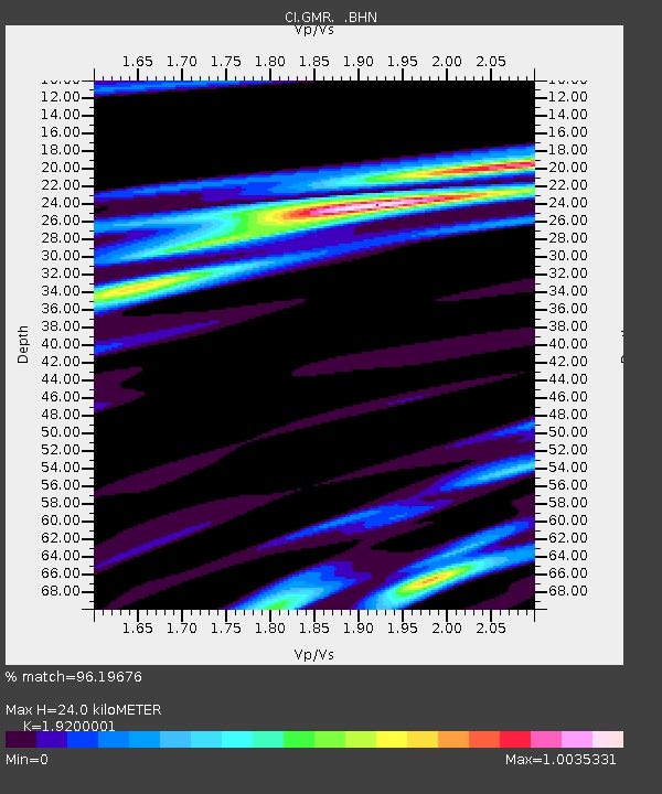
GMR Granite Mountains Research Center - Earthquake Result Viewer
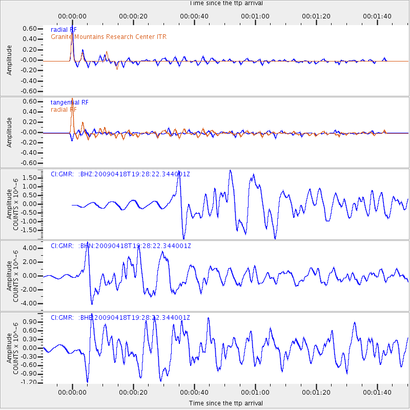
Earthquake location: Kuril Islands
Earthquake latitude/longitude: 46.0/151.4
Earthquake time(UTC): 2009/04/18 (108) 19:17:58 GMT
Earthquake Depth: 35 km
Earthquake Magnitude: 6.3 MB, 6.3 MS, 6.6 MW, 6.4 MW
Earthquake Catalog/Contributor: WHDF/NEIC
Network: CI Caltech Regional Seismic Network
Station: GMR Granite Mountains Research Center
Lat/Lon: 34.78 N/115.66 W
Elevation: 1326 m
Distance: 67.8 deg
Az: 62.618 deg
Baz: 311.253 deg
Ray Param: 0.056677073
Estimated Moho Depth: 24.0 km
Estimated Crust Vp/Vs: 1.92
Assumed Crust Vp: 6.276 km/s
Estimated Crust Vs: 3.269 km/s
Estimated Crust Poisson's Ratio: 0.31
Radial Match: 96.19676 %
Radial Bump: 315
Transverse Match: 82.516335 %
Transverse Bump: 400
SOD ConfigId: 2760
Insert Time: 2010-03-05 21:55:29.427 +0000
GWidth: 2.5
Max Bumps: 400
Tol: 0.001

Signal To Noise

ChannelStoNSTALTA
CI:GMR: :BHN:20090418T19:28:22.344001Z11.3768251.4362957E-61.262475E-7
CI:GMR: :BHE:20090418T19:28:22.344001Z2.91477253.0524217E-71.0472246E-7
CI:GMR: :BHZ:20090418T19:28:22.344001Z4.21471556.032962E-71.4314044E-7
Arrivals
Ps3.6 SECOND
PpPs11 SECOND
PsPs/PpSs14 SECOND