You are here: Home > Network List > TA - USArray Transportable Network (new EarthScope stations) Stations List
> Station 121A Cookes Peak, Deming, NM, USA > Earthquake Result Viewer
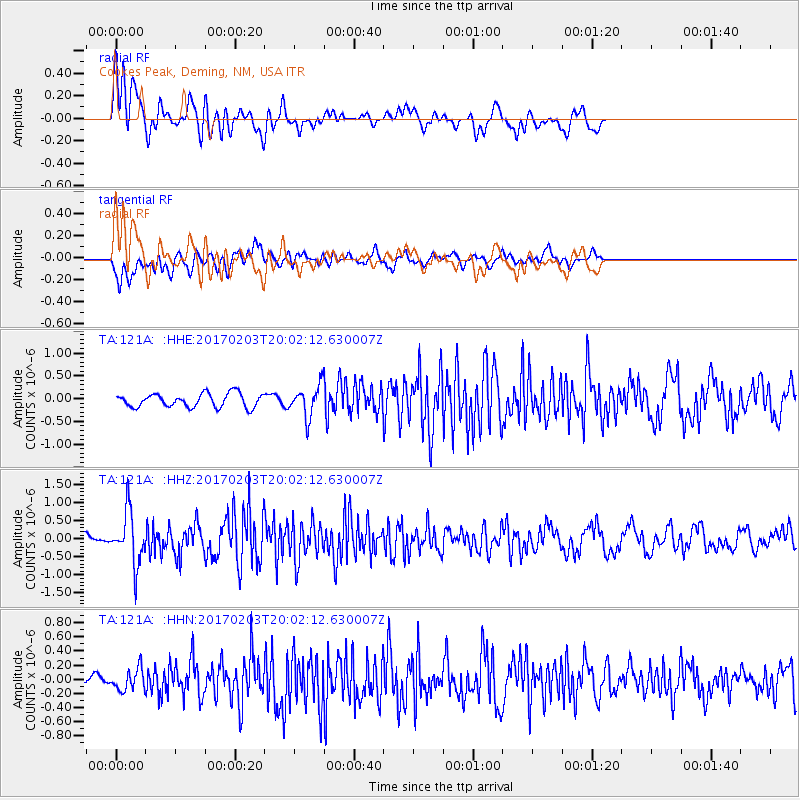
121A Cookes Peak, Deming, NM, USA - Earthquake Result Viewer
*The percent match for this event was below the threshold and hence no stack was calculated.
| Earthquake location: |
Leeward Islands |
| Earthquake latitude/longitude: |
15.1/-60.5 |
| Earthquake time(UTC): |
2017/02/03 (034) 19:54:21 GMT |
| Earthquake Depth: |
35 km |
| Earthquake Magnitude: |
5.6 Mwb |
| Earthquake Catalog/Contributor: |
NEIC PDE/us |
|
| Network: |
TA USArray Transportable Network (new EarthScope stations) |
| Station: |
121A Cookes Peak, Deming, NM, USA |
| Lat/Lon: |
32.53 N/107.79 W |
| Elevation: |
1652 m |
|
| Distance: |
46.2 deg |
| Az: |
300.716 deg |
| Baz: |
100.551 deg |
| Ray Param: |
$rayparam |
*The percent match for this event was below the threshold and hence was not used in the summary stack. |
|
| Radial Match: |
61.789352 % |
| Radial Bump: |
400 |
| Transverse Match: |
63.0468 % |
| Transverse Bump: |
400 |
| SOD ConfigId: |
11737051 |
| Insert Time: |
2019-04-26 18:07:14.281 +0000 |
| GWidth: |
2.5 |
| Max Bumps: |
400 |
| Tol: |
0.001 |
|
Signal To Noise
| Channel | StoN | STA | LTA |
| TA:121A: :HHZ:20170203T20:02:12.630007Z | 3.6415002 | 7.094904E-7 | 1.9483464E-7 |
| TA:121A: :HHN:20170203T20:02:12.630007Z | 0.9362728 | 1.5363058E-7 | 1.6408741E-7 |
| TA:121A: :HHE:20170203T20:02:12.630007Z | 2.4297814 | 3.6326338E-7 | 1.4950454E-7 |
| Arrivals |
| Ps | |
| PpPs | |
| PsPs/PpSs | |


