You are here: Home > Network List > TA - USArray Transportable Network (new EarthScope stations) Stations List
> Station N23A Red Feather Lakes, CO, USA > Earthquake Result Viewer
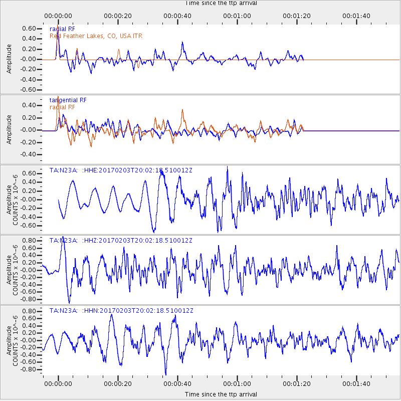
N23A Red Feather Lakes, CO, USA - Earthquake Result Viewer
*The percent match for this event was below the threshold and hence no stack was calculated.
| Earthquake location: |
Leeward Islands |
| Earthquake latitude/longitude: |
15.1/-60.5 |
| Earthquake time(UTC): |
2017/02/03 (034) 19:54:21 GMT |
| Earthquake Depth: |
35 km |
| Earthquake Magnitude: |
5.6 Mwb |
| Earthquake Catalog/Contributor: |
NEIC PDE/us |
|
| Network: |
TA USArray Transportable Network (new EarthScope stations) |
| Station: |
N23A Red Feather Lakes, CO, USA |
| Lat/Lon: |
40.89 N/105.94 W |
| Elevation: |
2458 m |
|
| Distance: |
47.0 deg |
| Az: |
312.349 deg |
| Baz: |
109.66 deg |
| Ray Param: |
$rayparam |
*The percent match for this event was below the threshold and hence was not used in the summary stack. |
|
| Radial Match: |
44.044453 % |
| Radial Bump: |
382 |
| Transverse Match: |
38.084015 % |
| Transverse Bump: |
400 |
| SOD ConfigId: |
11737051 |
| Insert Time: |
2019-04-26 18:07:35.972 +0000 |
| GWidth: |
2.5 |
| Max Bumps: |
400 |
| Tol: |
0.001 |
|
Signal To Noise
| Channel | StoN | STA | LTA |
| TA:N23A: :HHZ:20170203T20:02:18.510012Z | 5.045622 | 5.379867E-7 | 1.0662445E-7 |
| TA:N23A: :HHN:20170203T20:02:18.510012Z | 0.79264736 | 1.9310289E-7 | 2.4361765E-7 |
| TA:N23A: :HHE:20170203T20:02:18.510012Z | 2.3050716 | 4.823273E-7 | 2.0924612E-7 |
| Arrivals |
| Ps | |
| PpPs | |
| PsPs/PpSs | |


