You are here: Home > Network List > TA - USArray Transportable Network (new EarthScope stations) Stations List
> Station TUL1 Leonard, OK, USA > Earthquake Result Viewer
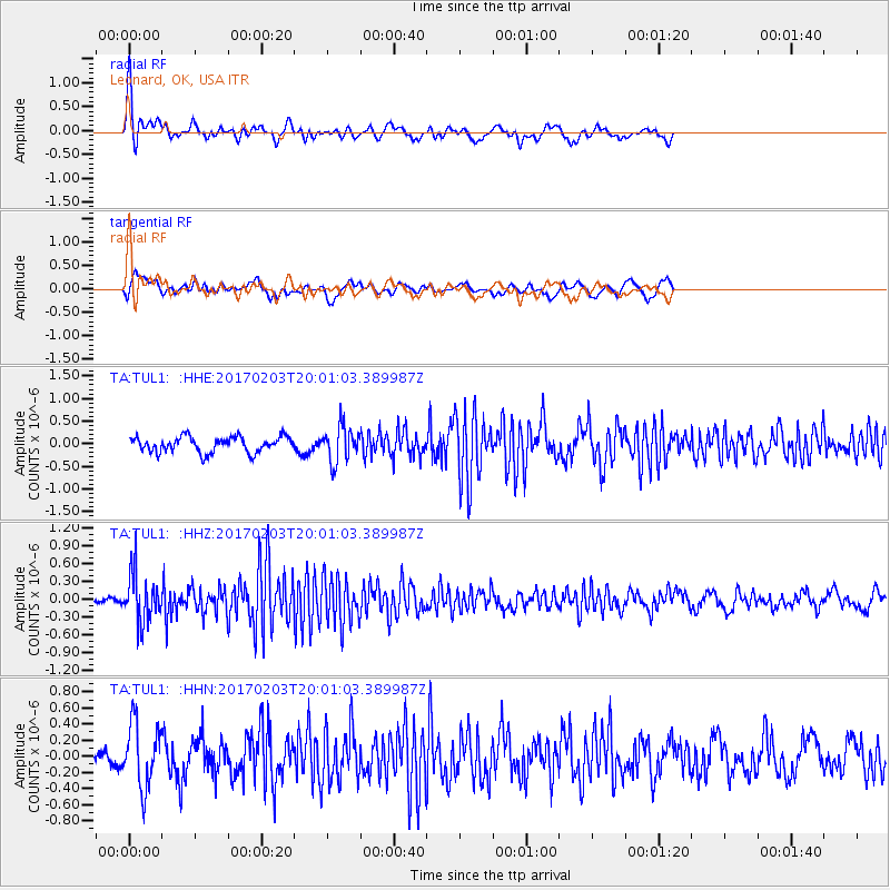
TUL1 Leonard, OK, USA - Earthquake Result Viewer
*The percent match for this event was below the threshold and hence no stack was calculated.
| Earthquake location: |
Leeward Islands |
| Earthquake latitude/longitude: |
15.1/-60.5 |
| Earthquake time(UTC): |
2017/02/03 (034) 19:54:21 GMT |
| Earthquake Depth: |
35 km |
| Earthquake Magnitude: |
5.6 Mwb |
| Earthquake Catalog/Contributor: |
NEIC PDE/us |
|
| Network: |
TA USArray Transportable Network (new EarthScope stations) |
| Station: |
TUL1 Leonard, OK, USA |
| Lat/Lon: |
35.91 N/95.79 W |
| Elevation: |
256 m |
|
| Distance: |
37.7 deg |
| Az: |
309.936 deg |
| Baz: |
114.167 deg |
| Ray Param: |
$rayparam |
*The percent match for this event was below the threshold and hence was not used in the summary stack. |
|
| Radial Match: |
75.82853 % |
| Radial Bump: |
308 |
| Transverse Match: |
54.444 % |
| Transverse Bump: |
389 |
| SOD ConfigId: |
11737051 |
| Insert Time: |
2019-04-26 18:07:52.373 +0000 |
| GWidth: |
2.5 |
| Max Bumps: |
400 |
| Tol: |
0.001 |
|
Signal To Noise
| Channel | StoN | STA | LTA |
| TA:TUL1: :HHZ:20170203T20:01:03.389987Z | 5.5619407 | 4.096423E-7 | 7.3650966E-8 |
| TA:TUL1: :HHN:20170203T20:01:03.389987Z | 2.3019907 | 3.9527617E-7 | 1.717106E-7 |
| TA:TUL1: :HHE:20170203T20:01:03.389987Z | 2.2577229 | 3.9150393E-7 | 1.7340655E-7 |
| Arrivals |
| Ps | |
| PpPs | |
| PsPs/PpSs | |


