You are here: Home > Network List > CI - Caltech Regional Seismic Network Stations List
> Station DAN DAN, Needles, CA, USA > Earthquake Result Viewer
DAN DAN, Needles, CA, USA - Earthquake Result Viewer
| Earthquake location: |
Fiji Islands Region |
| Earthquake latitude/longitude: |
-21.1/-176.6 |
| Earthquake time(UTC): |
2003/07/27 (208) 02:04:11 GMT |
| Earthquake Depth: |
213 km |
| Earthquake Magnitude: |
5.9 MB, 6.6 MW, 6.6 MW |
| Earthquake Catalog/Contributor: |
WHDF/NEIC |
|
| Network: |
CI Caltech Regional Seismic Network |
| Station: |
DAN DAN, Needles, CA, USA |
| Lat/Lon: |
34.64 N/115.38 W |
| Elevation: |
428 m |
|
| Distance: |
80.3 deg |
| Az: |
47.145 deg |
| Baz: |
236.128 deg |
| Ray Param: |
0.047846735 |
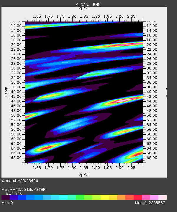
| Estimated Moho Depth: |
43.25 km |
| Estimated Crust Vp/Vs: |
2.03 |
| Assumed Crust Vp: |
6.276 km/s |
| Estimated Crust Vs: |
3.099 km/s |
| Estimated Crust Poisson's Ratio: |
0.34 |
|
| Radial Match: |
93.23696 % |
| Radial Bump: |
400 |
| Transverse Match: |
81.60843 % |
| Transverse Bump: |
400 |
| SOD ConfigId: |
3787 |
| Insert Time: |
2010-02-26 01:02:00.988 +0000 |
| GWidth: |
2.5 |
| Max Bumps: |
400 |
| Tol: |
0.001 |
|

Signal To Noise
| Channel | StoN | STA | LTA |
| CI:DAN: :BHN:20030727T02:15:27.501008Z | 1.3770736 | 1.2911006E-6 | 9.375683E-7 |
| CI:DAN: :BHE:20030727T02:15:27.501008Z | 1.540713 | 1.2538653E-6 | 8.1382154E-7 |
| CI:DAN: :BHZ:20030727T02:15:27.501008Z | 3.0273871 | 2.265389E-6 | 7.482984E-7 |
| Arrivals |
| Ps | 7.2 SECOND |
| PpPs | 20 SECOND |
| PsPs/PpSs | 28 SECOND |


