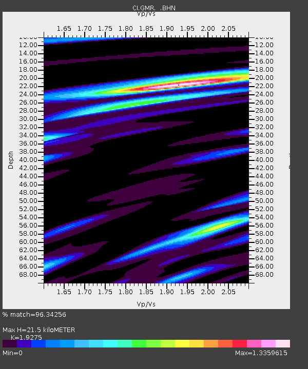
GMR Granite Mountains Research Center - Earthquake Result Viewer
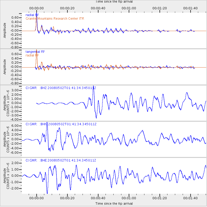
Earthquake location: Andreanof Islands, Aleutian Is.
Earthquake latitude/longitude: 51.9/-177.5
Earthquake time(UTC): 2008/05/02 (123) 01:33:37 GMT
Earthquake Depth: 14 km
Earthquake Magnitude: 6.3 MB, 6.8 MS, 6.6 MW, 6.6 MW
Earthquake Catalog/Contributor: WHDF/NEIC
Network: CI Caltech Regional Seismic Network
Station: GMR Granite Mountains Research Center
Lat/Lon: 34.78 N/115.66 W
Elevation: 1326 m
Distance: 46.7 deg
Az: 86.241 deg
Baz: 311.258 deg
Ray Param: 0.07049008
Estimated Moho Depth: 21.5 km
Estimated Crust Vp/Vs: 1.93
Assumed Crust Vp: 6.276 km/s
Estimated Crust Vs: 3.256 km/s
Estimated Crust Poisson's Ratio: 0.32
Radial Match: 96.34256 %
Radial Bump: 294
Transverse Match: 85.27408 %
Transverse Bump: 400
SOD ConfigId: 2504
Insert Time: 2010-03-05 21:57:16.994 +0000
GWidth: 2.5
Max Bumps: 400
Tol: 0.001

Signal To Noise

ChannelStoNSTALTA
CI:GMR: :BHN:20080502T01:41:34.345011Z4.20040751.2267905E-62.920646E-7
CI:GMR: :BHE:20080502T01:41:34.345011Z2.42451833.8729877E-71.5974256E-7
CI:GMR: :BHZ:20080502T01:41:34.345011Z5.1632047.311976E-71.4161702E-7
Arrivals
Ps3.4 SECOND
PpPs9.5 SECOND
PsPs/PpSs13 SECOND