You are here: Home > Network List > TA - USArray Transportable Network (new EarthScope stations) Stations List
> Station L20K Farewell, AK, USA > Earthquake Result Viewer
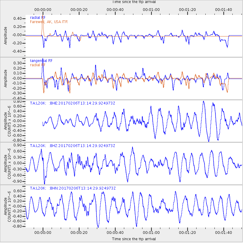
L20K Farewell, AK, USA - Earthquake Result Viewer
*The percent match for this event was below the threshold and hence no stack was calculated.
| Earthquake location: |
Colombia |
| Earthquake latitude/longitude: |
3.4/-74.7 |
| Earthquake time(UTC): |
2017/02/06 (037) 13:02:45 GMT |
| Earthquake Depth: |
38 km |
| Earthquake Magnitude: |
5.5 Mww |
| Earthquake Catalog/Contributor: |
NEIC PDE/us |
|
| Network: |
TA USArray Transportable Network (new EarthScope stations) |
| Station: |
L20K Farewell, AK, USA |
| Lat/Lon: |
62.48 N/153.88 W |
| Elevation: |
673 m |
|
| Distance: |
82.0 deg |
| Az: |
332.559 deg |
| Baz: |
97.997 deg |
| Ray Param: |
$rayparam |
*The percent match for this event was below the threshold and hence was not used in the summary stack. |
|
| Radial Match: |
55.133644 % |
| Radial Bump: |
400 |
| Transverse Match: |
77.961174 % |
| Transverse Bump: |
397 |
| SOD ConfigId: |
11737051 |
| Insert Time: |
2019-04-26 18:18:12.537 +0000 |
| GWidth: |
2.5 |
| Max Bumps: |
400 |
| Tol: |
0.001 |
|
Signal To Noise
| Channel | StoN | STA | LTA |
| TA:L20K: :BHZ:20170206T13:14:29.924973Z | 1.4397297 | 5.246549E-7 | 3.644121E-7 |
| TA:L20K: :BHN:20170206T13:14:29.924973Z | 0.9446258 | 2.3085977E-7 | 2.4439282E-7 |
| TA:L20K: :BHE:20170206T13:14:29.924973Z | 1.7111441 | 2.3939992E-7 | 1.3990636E-7 |
| Arrivals |
| Ps | |
| PpPs | |
| PsPs/PpSs | |


