You are here: Home > Network List > US - United States National Seismic Network Stations List
> Station WMOK Wichita Mountains, Oklahoma, USA > Earthquake Result Viewer
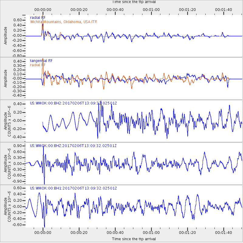
WMOK Wichita Mountains, Oklahoma, USA - Earthquake Result Viewer
*The percent match for this event was below the threshold and hence no stack was calculated.
| Earthquake location: |
Colombia |
| Earthquake latitude/longitude: |
3.4/-74.7 |
| Earthquake time(UTC): |
2017/02/06 (037) 13:02:45 GMT |
| Earthquake Depth: |
38 km |
| Earthquake Magnitude: |
5.5 Mww |
| Earthquake Catalog/Contributor: |
NEIC PDE/us |
|
| Network: |
US United States National Seismic Network |
| Station: |
WMOK Wichita Mountains, Oklahoma, USA |
| Lat/Lon: |
34.74 N/98.78 W |
| Elevation: |
486 m |
|
| Distance: |
38.3 deg |
| Az: |
327.165 deg |
| Baz: |
138.912 deg |
| Ray Param: |
$rayparam |
*The percent match for this event was below the threshold and hence was not used in the summary stack. |
|
| Radial Match: |
53.749992 % |
| Radial Bump: |
400 |
| Transverse Match: |
39.909016 % |
| Transverse Bump: |
400 |
| SOD ConfigId: |
11737051 |
| Insert Time: |
2019-04-26 18:19:13.239 +0000 |
| GWidth: |
2.5 |
| Max Bumps: |
400 |
| Tol: |
0.001 |
|
Signal To Noise
| Channel | StoN | STA | LTA |
| US:WMOK:00:BHZ:20170206T13:09:32.02501Z | 3.1710887 | 3.4993877E-7 | 1.1035288E-7 |
| US:WMOK:00:BH1:20170206T13:09:32.02501Z | 2.6867425 | 2.4276574E-7 | 9.03569E-8 |
| US:WMOK:00:BH2:20170206T13:09:32.02501Z | 1.890612 | 2.3832469E-7 | 1.260569E-7 |
| Arrivals |
| Ps | |
| PpPs | |
| PsPs/PpSs | |


