You are here: Home > Network List > AG - Arkansas Seismic Network Stations List
> Station HHAR Hobbs,AR > Earthquake Result Viewer
HHAR Hobbs,AR - Earthquake Result Viewer
| Earthquake location: |
Off Coast Of Central Chile |
| Earthquake latitude/longitude: |
-29.4/-72.1 |
| Earthquake time(UTC): |
2015/11/11 (315) 01:54:37 GMT |
| Earthquake Depth: |
10 km |
| Earthquake Magnitude: |
6.9 MWW, 6.6 MI |
| Earthquake Catalog/Contributor: |
NEIC PDE/NEIC COMCAT |
|
| Network: |
AG Arkansas Seismic Network |
| Station: |
HHAR Hobbs,AR |
| Lat/Lon: |
36.28 N/93.94 W |
| Elevation: |
421 m |
|
| Distance: |
68.5 deg |
| Az: |
341.159 deg |
| Baz: |
159.596 deg |
| Ray Param: |
0.056248713 |
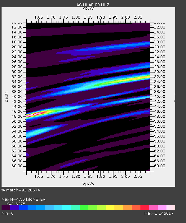
| Estimated Moho Depth: |
47.0 km |
| Estimated Crust Vp/Vs: |
1.63 |
| Assumed Crust Vp: |
6.53 km/s |
| Estimated Crust Vs: |
4.013 km/s |
| Estimated Crust Poisson's Ratio: |
0.20 |
|
| Radial Match: |
93.20674 % |
| Radial Bump: |
315 |
| Transverse Match: |
66.169266 % |
| Transverse Bump: |
400 |
| SOD ConfigId: |
1259291 |
| Insert Time: |
2015-11-25 02:14:39.907 +0000 |
| GWidth: |
2.5 |
| Max Bumps: |
400 |
| Tol: |
0.001 |
|

Signal To Noise
| Channel | StoN | STA | LTA |
| AG:HHAR:00:HHZ:20151111T02:05:09.004983Z | 5.496178 | 9.127794E-7 | 1.660753E-7 |
| AG:HHAR:00:HHN:20151111T02:05:09.004983Z | 1.846628 | 3.9119314E-7 | 2.118419E-7 |
| AG:HHAR:00:HHE:20151111T02:05:09.004983Z | 1.5624486 | 3.2030778E-7 | 2.0500372E-7 |
| Arrivals |
| Ps | 4.7 SECOND |
| PpPs | 18 SECOND |
| PsPs/PpSs | 23 SECOND |


