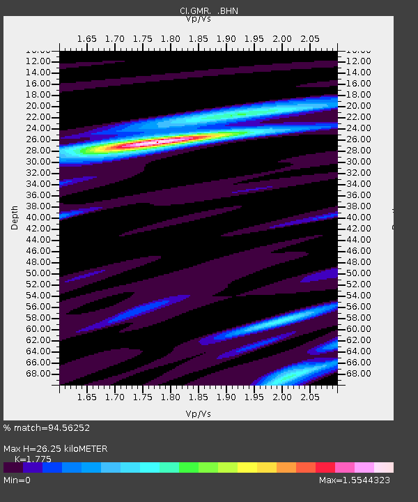
GMR Granite Mountains Research Center - Earthquake Result Viewer
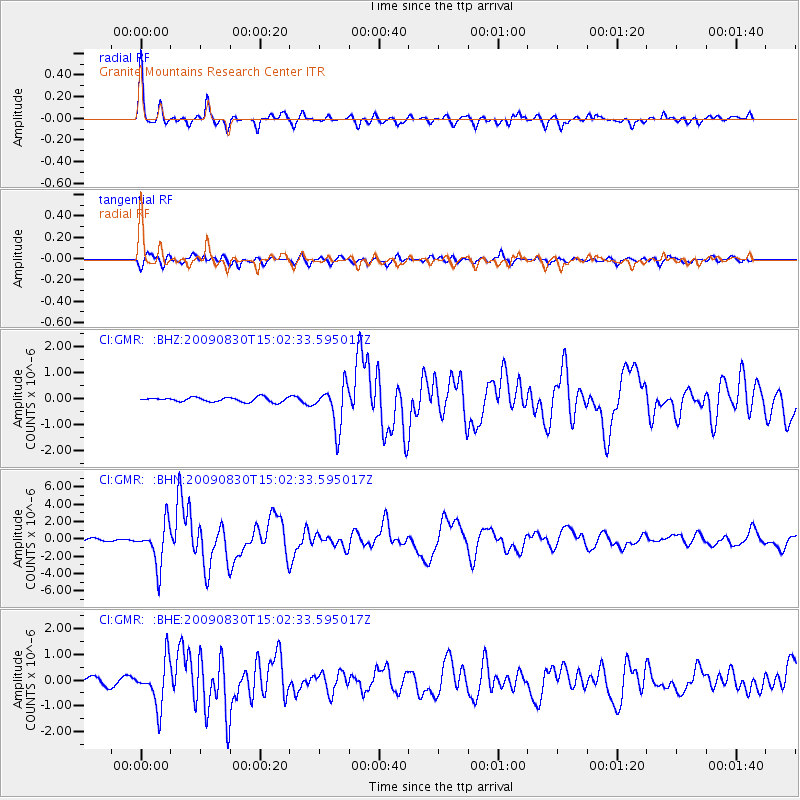
Earthquake location: Samoa Islands Region
Earthquake latitude/longitude: -15.2/-172.6
Earthquake time(UTC): 2009/08/30 (242) 14:51:32 GMT
Earthquake Depth: 11 km
Earthquake Magnitude: 6.4 MB, 6.3 MS, 6.6 MW, 6.6 MW
Earthquake Catalog/Contributor: WHDF/NEIC
Network: CI Caltech Regional Seismic Network
Station: GMR Granite Mountains Research Center
Lat/Lon: 34.78 N/115.66 W
Elevation: 1326 m
Distance: 73.4 deg
Az: 46.02 deg
Baz: 237.56 deg
Ray Param: 0.05302391
Estimated Moho Depth: 26.25 km
Estimated Crust Vp/Vs: 1.77
Assumed Crust Vp: 6.276 km/s
Estimated Crust Vs: 3.536 km/s
Estimated Crust Poisson's Ratio: 0.27
Radial Match: 94.56252 %
Radial Bump: 339
Transverse Match: 86.92252 %
Transverse Bump: 400
SOD ConfigId: 2622
Insert Time: 2010-03-05 21:58:31.051 +0000
GWidth: 2.5
Max Bumps: 400
Tol: 0.001

Signal To Noise

ChannelStoNSTALTA
CI:GMR: :BHN:20090830T15:02:33.595017Z14.4501512.379232E-61.6465101E-7
CI:GMR: :BHE:20090830T15:02:33.595017Z5.9280418.8004333E-71.4845432E-7
CI:GMR: :BHZ:20090830T15:02:33.595017Z9.56078.0761896E-78.447278E-8
Arrivals
Ps3.3 SECOND
PpPs11 SECOND
PsPs/PpSs15 SECOND